
|
|
| ČESKÁ REPUBLIKA | CZECH REPUBLIC |
| Středočeský kraj | Central Bohemia region |
| Okres: Kolín |
map →
 Žiželice (pervious German name: Schischelitz) is situated at an elevation of 211 m on the river
Cidlina about 18 km northeast of the district town Kolín. The municipality has a population
of 713 (2021).
Žiželice (pervious German name: Schischelitz) is situated at an elevation of 211 m on the river
Cidlina about 18 km northeast of the district town Kolín. The municipality has a population
of 713 (2021).
The earliest written document that mentions Zuzelic dates from 1052. In 1850, was placed in the political district of Nový Bydžov, court district of Chlumec (Chlumec nad Cidlinou). In 1960 it was reassigned to the district Kolín.
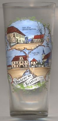
The top picture on glass no. 4486 [left] shows a view of the
 store
store
The view depicted on the bottom left picture is labeled
square,
The bottom right picture shows a view of
Kolín
The church of St. Prokop (Kostel svatého Prokopa) [bottom right picture: right]
goes back to a wooden church that had been built in the 13th century. When the lords of Rožmberk
acquired the local estate in 1347, the church was rebuilt as a stone on, approximately in its present condition. Further modifications were made in
1712 and then after the fire of 1830. The upper floor of the tower was only completed in 1959.
[https://cs.wikipedia.org/wiki/%C5%BDi%C5%BEelice_(okres_Kol%C3%ADn), https://fr.wikipedia.org/wiki/%C5%BDi%C5%BEelice_(district_de_Kol%C3%ADn);
https://cs.wikipedia.org/wiki/Kostel_svat%C3%A9ho_Prokopa_(%C5%BDi%C5%BEelice)]
![[scale]](lineal.jpg)