
|
|
| DEUTSCHLAND | GERMANY |
| Bundesland: Hessen | Hesse |
| Regierungsbezirk: Darmstadt | |
| Kreis: Hochtaunuskreis |
map →
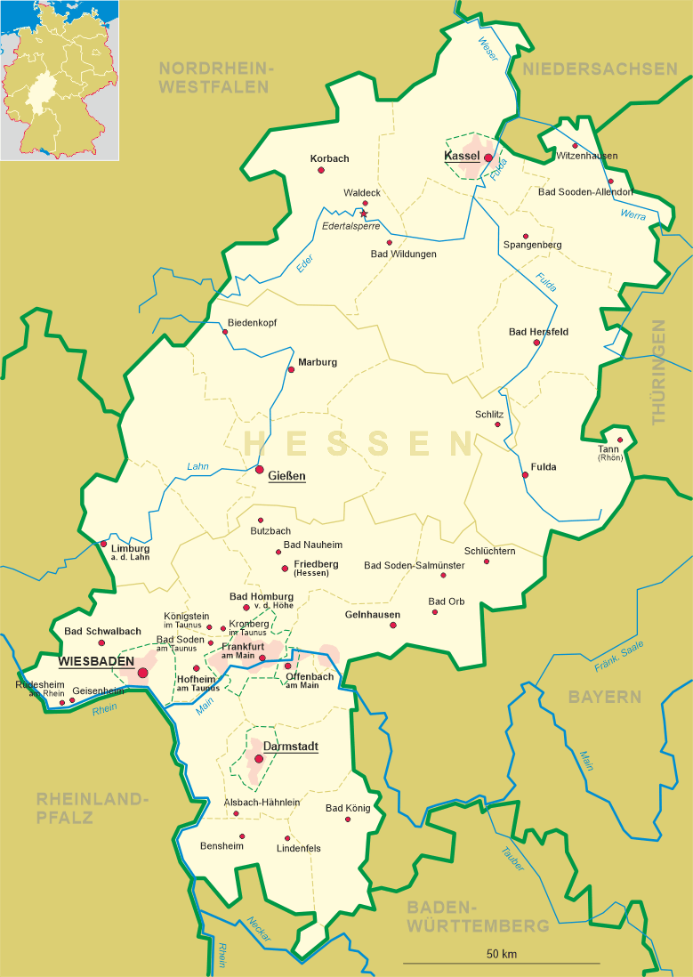
 Königstein im Taunus is situated at an elevation of 362 m in the southern foothills of the Taunus mountains about 12&nbsl;km
southwest of the district town Bad Homburg vor der Höhe, about 17 km northwest of Frankfurt am Main
and about 21 km northwest of Wiesbaden, the capital of Germany's state of Hesse. The municipality has a population of about
16,700 (2022).
Königstein im Taunus is situated at an elevation of 362 m in the southern foothills of the Taunus mountains about 12&nbsl;km
southwest of the district town Bad Homburg vor der Höhe, about 17 km northwest of Frankfurt am Main
and about 21 km northwest of Wiesbaden, the capital of Germany's state of Hesse. The municipality has a population of about
16,700 (2022).
A local legend states that King Chlodwig founded the place around 500, which usually is used as explanation of the origin of the name Königstein ('King's stone'). The earliest written document mentioning the place, however, dates from 1215. Königstein obtained the privileges of a town in 1313. By 1581, Königstein belonged to the Electorate of Mainz. Early in the 17th century, in connection with the Counterreformation, the castle was remodelled into a mighty fortress, but this newer military stronghold met its end in the French Revolutionary Wars when the French blew it up in 1796, although this may have been unintentional. In 1803, Königstein passed to the Principality of Nassau-Usingen, which itself later merged with Nassau-Weilburg to form the Duchy of Nassau. In 1866 it was annexed to Prussia. Following World War II, in 1946, it became part of the newly formed German state of Hesse. The full modern name Königstein im Taunus was made official in 1977.
The ruins of  Königstein castle [background centre], one of the largest castle ruins, are the landmark of
the city. The oldest traces of a settlement on the hill dates from the 10th or 11th century. The oldest parts of the core of the castle could be dated to the
first half of the 12th century. The lower parts of the castle keep date from the first half of the 14th century. Over time, the keep was heightened
several times and today its remnants have a height of 34 meters. The castle was rebuilt and enlarged numerous times throughout the ensuing centuries. In
1581 the castle came in possession of the electorate of Mainz, and from then on it was only used for military purposes any more. The last larger addition was
a bastion constructed in 1670. In 1972, the castle was conquered by the French. Besieged by the Prussians, the French finally surrendered in the following
year. After 1796, the castle was used as a quarry by the citizens of Königstein who needed materials for the reconstruction of the city following the
large fire that destroyed large parts of the town in December 1972. After the Reichsdeputationshauptschluss of of 1803, the castle came in possession of
the duchy of Nassau, but the dukes decided not to rebuild the fortress and tolerated the continuation of the demolition. Even after the annexation of Nassau
by Prussia, the castle remained a personal property of the Nassau family. In 1922, the family donated the castle ruins to the city of Königstein. Today,
the ruins are open to the public.
Königstein castle [background centre], one of the largest castle ruins, are the landmark of
the city. The oldest traces of a settlement on the hill dates from the 10th or 11th century. The oldest parts of the core of the castle could be dated to the
first half of the 12th century. The lower parts of the castle keep date from the first half of the 14th century. Over time, the keep was heightened
several times and today its remnants have a height of 34 meters. The castle was rebuilt and enlarged numerous times throughout the ensuing centuries. In
1581 the castle came in possession of the electorate of Mainz, and from then on it was only used for military purposes any more. The last larger addition was
a bastion constructed in 1670. In 1972, the castle was conquered by the French. Besieged by the Prussians, the French finally surrendered in the following
year. After 1796, the castle was used as a quarry by the citizens of Königstein who needed materials for the reconstruction of the city following the
large fire that destroyed large parts of the town in December 1972. After the Reichsdeputationshauptschluss of of 1803, the castle came in possession of
the duchy of Nassau, but the dukes decided not to rebuild the fortress and tolerated the continuation of the demolition. Even after the annexation of Nassau
by Prussia, the castle remained a personal property of the Nassau family. In 1922, the family donated the castle ruins to the city of Königstein. Today,
the ruins are open to the public.
Another glass of this collection shows a view of Königstein (Sächsische Schweiz).
[https://de.wikipedia.org/wiki/K%C3%B6nigstein_im_Taunus, https://en.wikipedia.org/wiki/K%C3%B6nigstein_im_Taunus]
![[scale]](lineal.jpg)