
|
|
| ÖSTERREICH | AUSTRIA |
| Bundesland: Steiermark | Styria |
| Bezirk: Murtal |
map →

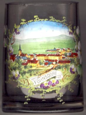 Fohnsdorf is situated at an elevation of 736 m in the upper Mur valley in the Murtal district
(combined in 2012 out of the districts Judenburg
and Knittelfeld) in Upper Styria.
The old fortified market town had been destroyed in 1289. From the 17th century onward
Fohnsdorf became a centre of coal mining. Until its closure in 1978, Fohnsdorf
could boast the world's deepest brown coal mining shaft (depth 1,130 m).
The shafthead frame, parts of the machine rooms and some of the tunnels now are
part of the mining museum.
Fohnsdorf is situated at an elevation of 736 m in the upper Mur valley in the Murtal district
(combined in 2012 out of the districts Judenburg
and Knittelfeld) in Upper Styria.
The old fortified market town had been destroyed in 1289. From the 17th century onward
Fohnsdorf became a centre of coal mining. Until its closure in 1978, Fohnsdorf
could boast the world's deepest brown coal mining shaft (depth 1,130 m).
The shafthead frame, parts of the machine rooms and some of the tunnels now are
part of the mining museum.
The  parish church Sankt Rupert [left]
was first mentioned in a document of 1147. The walls of the nave and the church tower between chancel and nave
date from the Romanesque period, the vaulting of the nave and the chancel are
from the Late Gothic period.
parish church Sankt Rupert [left]
was first mentioned in a document of 1147. The walls of the nave and the church tower between chancel and nave
date from the Romanesque period, the vaulting of the nave and the chancel are
from the Late Gothic period.
![[scale]](lineal.jpg)