
|
|
| ÖSTERREICH | AUSTRIA |
| Bundesland: Steiermark | Styria |
| Bezirk: Südoststeiermark |
map →

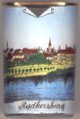 Radkersburg was founded 1261-1265 by King Ottokar II of Bohemia as a fortification
guarding the border to Hungary together with the castle Oberradkersburg (today Gornja Radgona, SLO)
on the other side of the river Mur. The medieval fortifications were enlarged by Domenico Dell'Allio
between 1546 and 1591. From 1773 the fortifications were not used any more, but large parts are still remaining.
Although the town was heavily damaged 1945, almost the entire old town was spared.
Radkersburg was founded 1261-1265 by King Ottokar II of Bohemia as a fortification
guarding the border to Hungary together with the castle Oberradkersburg (today Gornja Radgona, SLO)
on the other side of the river Mur. The medieval fortifications were enlarged by Domenico Dell'Allio
between 1546 and 1591. From 1773 the fortifications were not used any more, but large parts are still remaining.
Although the town was heavily damaged 1945, almost the entire old town was spared.
The cold spring found 1927 has been used since 1960 (Radkersburger Stadtquelle) as Austria's only spa for diseases of the kidney. In 1978 the town received the predicate Bad. In the same year the hot spring, which is among the hottest in Europe, was discovered. On 1 January 2013 the former districts Feldbach and Radkersburg were merged into the new district Südoststeiermark (Southeast Styria); the capital of the new district is Feldbach. In 2015 the neighbouring municipality of Radkersburg Umgebung was incorporated into the municipality of Bad Radkersburg.
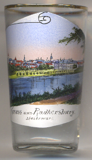
The tower of the  town hall
[left, no. 186: background centre, barely visible] is the popular landmark of Bad Radkersburg.
the town hall was built in the 15th to 17th century, the façade dates from the 19th century. The lower parts of
the octogonal tower, accentuating the corner of the building, were creating around 1500 in the late Gothic style. This part of
the tower survived the large fire of 1750, while the upper parts that were added in the Renaissance period were destroyed
during this disaster and were later replaced in late Baroque style in 1805.
town hall
[left, no. 186: background centre, barely visible] is the popular landmark of Bad Radkersburg.
the town hall was built in the 15th to 17th century, the façade dates from the 19th century. The lower parts of
the octogonal tower, accentuating the corner of the building, were creating around 1500 in the late Gothic style. This part of
the tower survived the large fire of 1750, while the upper parts that were added in the Renaissance period were destroyed
during this disaster and were later replaced in late Baroque style in 1805.
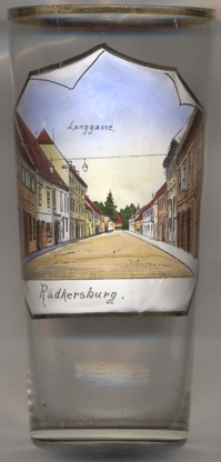
The picture on glass no. 4244 [near left] shows a view of the street
Langgasse.
[https://de.wikipedia.org/wiki/Bad_Radkersburg;
https://www.historischerverein-stmk.at/wp-content/uploads/Z_Jg97_Hermann-KURAHS-Herrenhof-Kirche-und-Rathaus.pdf;
https://de.wikipedia.org/wiki/Rathaus_Bad_Radkersburg]
![[scale]](lineal.jpg)