
|
|
| DEUTSCHLAND | GERMANY |
| Bundesland: Baden-Württemberg | |
| Regierungsbezirk: Freiburg | |
| Landkreis: Schwarzwald-Baar-Kreis |
map →

The district town Villingen-Schwenningen is situated at an elevation of 660–995 m in the southern Schwarzwald (Black Forest) region of Germany's state Baden-Württemberg. The municipality was formed in 1972 by the amalgamation of the formerly independent towns of Villingen and Schwenningen.
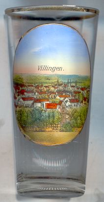 Villingen (Filingun) was first mentioned in a document in AD 817 and obtained the privileges of a market town in AD 999.
From 1326 until 1797/1803, Villingen was part of the Austrian territories. The Peace of Campio-Formio (1797) stipulated that Villingen had to be
handed over to the Duke of Mantova, which was finally accepted by Austria in 1803. In 1806, Villingen at first became part of Württemberg,
but within the same years was acquired by the Grand Duchy of Baden in exchange with
Biberach an der Riß.
The modern development of the town was greatly furthered by the opening of the Black Forest railroad in 1869–1873. Since 1937, Villingen also
was a recognized spa town for cold water cures.
Villingen (Filingun) was first mentioned in a document in AD 817 and obtained the privileges of a market town in AD 999.
From 1326 until 1797/1803, Villingen was part of the Austrian territories. The Peace of Campio-Formio (1797) stipulated that Villingen had to be
handed over to the Duke of Mantova, which was finally accepted by Austria in 1803. In 1806, Villingen at first became part of Württemberg,
but within the same years was acquired by the Grand Duchy of Baden in exchange with
Biberach an der Riß.
The modern development of the town was greatly furthered by the opening of the Black Forest railroad in 1869–1873. Since 1937, Villingen also
was a recognized spa town for cold water cures.
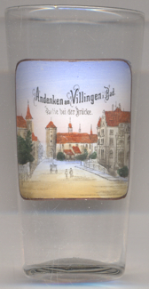
The  Bicken convent [near left, no. 3253: background right] was founded originally after 1255
at this place as a nunnery of the Poor Clares. After the dissolution of the Poor Clares' nunnery in 1782, it became an
Ursuline convent in the same year. The convent was finally closed in 2015 and the complex came in possession of the
archdiocese of Freiburg.
Bicken convent [near left, no. 3253: background right] was founded originally after 1255
at this place as a nunnery of the Poor Clares. After the dissolution of the Poor Clares' nunnery in 1782, it became an
Ursuline convent in the same year. The convent was finally closed in 2015 and the complex came in possession of the
archdiocese of Freiburg.
The Bickentor (Bicken Gate) [background, to the left of the Bicken convent]
was built around 1260 and today has a height of 18 metres.
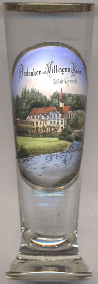
Hotel Kirneck [near left, no. 2790] was opened in the late 19th century in the main building of a former hammer mill, which in turn had replaced a fulling mill around 1830.
The hammer mill had been closed around 1870 and for a time was used to operate a rag tearing machine. Albert Schweitzer stayed in the hotel for his honeymoon in 1912.
The hotel later became a recreation home for the Grundig company under the name "Haus Annelie", named for Anneliese ("Annelie") Grundig, née Jürgensen, second wife of the
electronics company's founder, Max Grundig. The hotel was demolished around 1980.
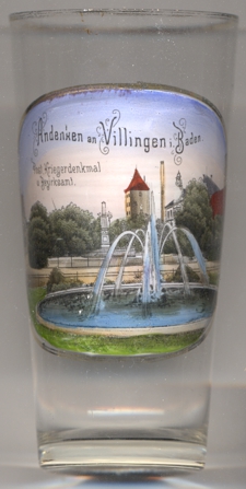
Glass no. 4107 [near left] shows a view that is labeled Post, Kriegerdenkmal u. Bezirksamt (Post office,
Soldiers' monument and District office).
The Soldiers' monument of Villingen [centre], located in front of the Bickentor in Kaiserring
(at the time still named Poststraße), commemorated
the French-German
War of 1870/1871. The monument was commissioned in 1874 and was created by the sculptor Joseph Ummendorfer. The monument was
unveiled on 5 September 1875.
The Imperial Post office [far left, barely visible] was rebuilt in 1903. The eastern part of the ring road,
until then named Poststraße, was renamed Kaiserring in 1904. The building rebuilt again in 1927. The main post office moved to Bahnhofstraße
in 1967. The building remained in use by the German Federal Post for internal purposes and was replaced by a modern building in 2004.
The Kaiserturm (Emperor's Tower) [background centre] was built in 1372 as part of Villingen's city wall.
The tower has a height of 31 metres. From the 19th century the tower served as living space, from 1949 also as a meeting room for young people.
The tower was renovagted in 1992 and 1994 and today houses a small museum.
The former district office of the district Villingen is shown in the background on the far right side of the picture.
(No further information could be found on this building.)
 Schwenningen was first mentioned in a document dating from AD 817.
In 1444 it became part of Württemberg and was placed in the Amt and Oberamt (district) Tuttlingen.
During the Peasants' War of 1525, Villingen (see above) attacked the village Schwenningen and almost completely destroyed it.
The saltern Wilhelmshall (located in today's Salinenstraße) was founded in 1824.
In 1830 Schwenningen obtained the status of a market town.
In 1842 the area of Schwenningen was removed from the Oberamt Tuttlingen and was placed in the Oberamt (today Landkreis) Rottweil.
The first clock manufacture was founded in 1858 and several more were founded in the following decades so that Schwenningen became well known as 'the world's largest
clock town'. The railroad from Rottweil to Schwenningen and Villingen was opened in 1869. In 1907, Schwenningen finally obtained the status of a town (while before it
had become known as the largest village of Württemberg). In 1972 Schwenningen was merged with Villingen to become the city of Villingen-Schwennningen.
Schwenningen was first mentioned in a document dating from AD 817.
In 1444 it became part of Württemberg and was placed in the Amt and Oberamt (district) Tuttlingen.
During the Peasants' War of 1525, Villingen (see above) attacked the village Schwenningen and almost completely destroyed it.
The saltern Wilhelmshall (located in today's Salinenstraße) was founded in 1824.
In 1830 Schwenningen obtained the status of a market town.
In 1842 the area of Schwenningen was removed from the Oberamt Tuttlingen and was placed in the Oberamt (today Landkreis) Rottweil.
The first clock manufacture was founded in 1858 and several more were founded in the following decades so that Schwenningen became well known as 'the world's largest
clock town'. The railroad from Rottweil to Schwenningen and Villingen was opened in 1869. In 1907, Schwenningen finally obtained the status of a town (while before it
had become known as the largest village of Württemberg). In 1972 Schwenningen was merged with Villingen to become the city of Villingen-Schwennningen.
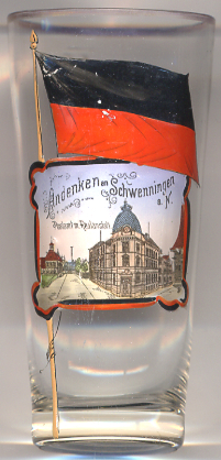
The former Realanstalt [left, no. 2887: centre]
was founded in 1839 as Realschule (secondary modern school). The building depicted on glass noo.2887 was built in 1901–1902. From 1904/05 the school also admitted girls.
In 1954 the school became a Gymnasium (grammar school). Due to lack of space a new, modern, school building was built in 1965 at the Deutenberg on the eastern edge of Schwenningen.
Since 1972, the official name of the school is Gymnasium am Deutenberg. The old school building toda is home of the Janusz-Korczak-Schule, a school for special education.
The building depicted in the left background of glass no. 2887 is labeled
Postamt
The black-and-red flag painted on glass n.2887 is the flag of the kingdom of Württemberg (1806–1918). After the end of the monarchy in 1918, the flag remained in use as the flag of the Volksstaat (People's State) Württemberg (1919–1945). After World War II, the flag became the flag of Württemberg-Hohenzollern, i.e. the southern part of former Württemberg and the former Prussian province Hohenzollern.
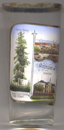
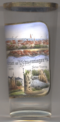 The picture on glass no. 3061 [left] shows several views of Schwenningen, with a panoramic view of
the town shown on top.
The picture on glass no. 3061 [left] shows several views of Schwenningen, with a panoramic view of
the town shown on top.
The Hölzle-König [left picture]
was a famous silver fir tree near Schwenningen. The labeling of the picture reads: “Hölzle-König /
Größte Tanne Deutschlands 58 Fstmtr.” (‘tallest fir tree in Germany, 58 solid cubic metres’).
After 1870, a storm tore down the two main tree tops, in 1915 a hailstorm bent the tree, and in 1941 the rotten
tree trunk finally fell in on itself. The tree had an age of more than 400 years.
The bottom centre picture shows a view of the
Fachschule
The bottom right picture shows a view of the
source of the river Neckar
[https://de.wikipedia.org/wiki/Villingen-Schwenningen;
https://de.wikipedia.org/wiki/Kloster_St._Clara_(Bickenkloster;
https://www.badische-seiten.de/villingen-schwenningen/bickentor-villingen.php;
https://www.nq-online.de/lokales/feiern-in-der-bierhalle-und-ein-obelisk_50_111856171-16.html;
http://wiki.ghv-villingen.de/?p=1453;
https://www.alemannische-seiten.de/deutschland/villingen-schwenningen_kaiserturm-villingen.php;
http://www.suedkurier.de/region/schwarzwald-baar-heuberg/villingen-schwenningen/hintergrund-villingen-schwenningen/Die-Historie-des-alten-Hammerwerks;art483522,4418739;
http://www.koenigsfeld.org/detail.php?ref=bb1&id=38 A.Schweitzer;
https://de.wikipedia.org/wiki/Gymnasium_am_Deutenberg_Villingen-Schwenningen;
http://www.schwarzwaelder-bote.de/inhalt.auf-gut-schwaebisch-schwenningens-hoelzlekoenig.b0a2d735-ef45-4ef6-a69d-79b9a3153f61.html;
http://www.rollstuhlwandern-in-bw.de/de/print.php?t=102&PHPSESSID=420dlt387mo90cphhavtdsbvr6, http://www.neckarkiesel.de/verlauf/]
![[scale]](lineal.jpg)