
|
|
| DEUTSCHLAND | GERMANY |
| Bundesland: Baden-Württemberg | |
| Regierungsbezirk: Freiburg | |
| Landkreis: Lörrach |
map →

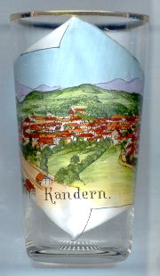 Kandern is situated at an elevation of 438 m between the Lippisbach stream and the river Kander
in the heart of the Markgräfler Land region of southwestern Baden-Württemberg. The municipality has a population
of about 8,200 (2018).
Kandern is situated at an elevation of 438 m between the Lippisbach stream and the river Kander
in the heart of the Markgräfler Land region of southwestern Baden-Württemberg. The municipality has a population
of about 8,200 (2018).
Cancer was first mentioned in the Codex Laureshamensis of AD 776. In 1503 it became part of the margraviate of Baden. Kandern obtained the status of a town in 1810. At the same time it became the seat of the administration of a district, which, however, was dissolved already in 1819. Kadern was part of the district Müllheim until 1972 when this district was merged into the present district Lörrach. The present municipality was formed in 1974 when Kandern was merged with the neighbouring municipalities of Feuerbach, Holzen, Riedlingen, Sitzenkirch, Tannenkirch and Wollbach. Since 1974 it has a joint administration with Malsburg-Marzell.
 The
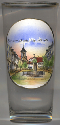
The  Protestant town church [left, no. 3855: background]
was built in 1825–1827. The oldest written document mentioning a church at this place dates from 1083.
The Romanesque arch of the entrance gate of what today is the cemetary chapel may even date from the 9th century.
The church that was replaced by the present church most probably had been built in the 14th century.
Protestant town church [left, no. 3855: background]
was built in 1825–1827. The oldest written document mentioning a church at this place dates from 1083.
The Romanesque arch of the entrance gate of what today is the cemetary chapel may even date from the 9th century.
The church that was replaced by the present church most probably had been built in the 14th century.
The sandstone fountain in the market square dates from 1813.
[https://de.wikipedia.org/wiki/Kandern, http://www.malsburg-marzell.de/;
https://de.wikipedia.org/wiki/Evangelische_Kirche_Kandern;
https://www.kandern.de/seite/365919/stadtrundgang.html]
![[scale]](lineal.jpg)