
|
|
| DEUTSCHLAND | GERMANY |
| Bundesland: Niedersachsen | Lower Saxony |
| Stadt: Emden |
map →
 Emden is situated in the estuary of the river Ems. The Frisian trading settlement Amuthon was founded around AD 800.
Protected by the Frankonian Kingdom it gained great importance as a trading town especially from the mid-11th century onward.
The place was ruled by local chieftains, even after the area was formally integrated into the jurisdiction of the bishops of Münster.
By 1412 Emden had gained control over the Ems estuary.
Because Emden gave shelter to buccaneers, it was attacked several times by Hamburg during the early 15th century.
In 1464 Emden became the residence of the new counts of East Frisia.
in 1495 Emden was granted an own coat of arms, which today is taken as the foundation of the city of Emden.
From the mid-16th century on, Emden became a port of major importance, especially after the town gave refuge to the Protestants
expelled from the Netherlands, and the blockade of the Dutch ports by Spain.
In 1595 the town regained its autonomy from the East Frisian counts. In 1744 Emden became Prussian, in 1806 it became part of the Netherlands,
between 1810 and 1815 it was ruled by France before it became part of the Kingdom of Hannover in 1815.
After the defeat of Hannover against Prussia in 1866 it became part of the Prussian province Hannover.
During World War II about 80% of the old town were destroyed.
Emden is situated in the estuary of the river Ems. The Frisian trading settlement Amuthon was founded around AD 800.
Protected by the Frankonian Kingdom it gained great importance as a trading town especially from the mid-11th century onward.
The place was ruled by local chieftains, even after the area was formally integrated into the jurisdiction of the bishops of Münster.
By 1412 Emden had gained control over the Ems estuary.
Because Emden gave shelter to buccaneers, it was attacked several times by Hamburg during the early 15th century.
In 1464 Emden became the residence of the new counts of East Frisia.
in 1495 Emden was granted an own coat of arms, which today is taken as the foundation of the city of Emden.
From the mid-16th century on, Emden became a port of major importance, especially after the town gave refuge to the Protestants
expelled from the Netherlands, and the blockade of the Dutch ports by Spain.
In 1595 the town regained its autonomy from the East Frisian counts. In 1744 Emden became Prussian, in 1806 it became part of the Netherlands,
between 1810 and 1815 it was ruled by France before it became part of the Kingdom of Hannover in 1815.
After the defeat of Hannover against Prussia in 1866 it became part of the Prussian province Hannover.
During World War II about 80% of the old town were destroyed.
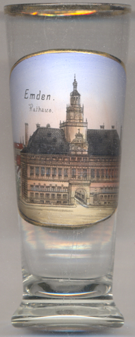
The  old town hall [left, no. 3353, and right, no. 1411] was built
in 1574–1576 by Laurens Steenwinkel from Antwerp in Renaissance style. For centuries the
impressive building testified of Emden's wealth as a trading town. During World War II the town hall was completely
destroyed in 1944. In 1959–1962 the building was rebuilt with much less details. It now serves as a museum, housing the
East Frisian regional museum, the collection of the old Emden armoury, and the city archives.
old town hall [left, no. 3353, and right, no. 1411] was built
in 1574–1576 by Laurens Steenwinkel from Antwerp in Renaissance style. For centuries the
impressive building testified of Emden's wealth as a trading town. During World War II the town hall was completely
destroyed in 1944. In 1959–1962 the building was rebuilt with much less details. It now serves as a museum, housing the
East Frisian regional museum, the collection of the old Emden armoury, and the city archives.
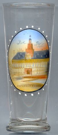
 The Ratsdelft [left, no. 2805: top picture] (or, as labeled on glass no. 2805, Rathausdelft)
is part of the Emden Harbour.
It began to develop after AD 800 where the small river Ehe flows into the Ems river. The name Delft (derived from delven, i.e. dig)
refers to the artificial modification of a natural waterbody. Until about 1870 the Ratsdelft and the Falderndelft formed the centre of the Frisian
and Westfrisian trade. During the 'Golden Age' of Emden (about 1561 until 1611) it was home to more ships than were owned by the entire English kingdom.
Around 1900 the back part of the Ratsdelft and its connection with the 'Alter Graben' were filled up in order to create the Stadtgarten (Municipal Park).
Today, the Ratsdelft is used as anchorage for three museum ships: the Lightvessel 'Amrumbank', the Lifeboat cruiser 'Georg Breusing' and the herring lugger 'Stadt Emden'
and as landing place for harbour tours.
The Ratsdelft [left, no. 2805: top picture] (or, as labeled on glass no. 2805, Rathausdelft)
is part of the Emden Harbour.
It began to develop after AD 800 where the small river Ehe flows into the Ems river. The name Delft (derived from delven, i.e. dig)
refers to the artificial modification of a natural waterbody. Until about 1870 the Ratsdelft and the Falderndelft formed the centre of the Frisian
and Westfrisian trade. During the 'Golden Age' of Emden (about 1561 until 1611) it was home to more ships than were owned by the entire English kingdom.
Around 1900 the back part of the Ratsdelft and its connection with the 'Alter Graben' were filled up in order to create the Stadtgarten (Municipal Park).
Today, the Ratsdelft is used as anchorage for three museum ships: the Lightvessel 'Amrumbank', the Lifeboat cruiser 'Georg Breusing' and the herring lugger 'Stadt Emden'
and as landing place for harbour tours.
[https://de.wikipedia.org/wiki/Ratsdelft]
The bottom left picture on glass no. 2805 [left] shows one of Emden's historic windmills,
presumably the windmill
[https://de.wikipedia.org/wiki/Emder_Mühlen]
The bottom right picture on glass no. 2805 [left] shows the,
lighthouse
[https://de.wikipedia.org/wiki/Leuchtturm_Emden_Westmole]
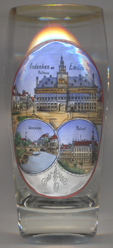 The bottom left picture on glass no. 3486 [near left] shows the bridge
Osterpiepe
The bottom left picture on glass no. 3486 [near left] shows the bridge
Osterpiepe
[http://www.landesmuseum-emden.de/255-0-46;
https://www.emderzeitung.de/emden/~/die-osterpiepe-bleibt-dauerhaft-erhalten-im-untergrund-303147/;
https://www.ostfriesischelandschaft.de/fileadmin/af/emd08.htm;
https://www.emderzeitung.de/emden/~/historische-bruecke-bei-bauarbeiten-freigelegt-302503/]
The bottom right picture on glass no. 3486 [near left] shows the old
Imperial post office Imperial telegraph office
[https://www.emden.de/fileadmin/media/stadtemden/PDF/Stadtarchiv/IV_reg.pdf;
http://bildarchiv.jalb.de/index.php/Alt-Emden/Lfd-Nr-07/JALB-Alt-Emden-0010-01]
![[scale]](lineal.jpg)