
|
|
| DEUTSCHLAND | GERMANY |
| Bundesland: Brandenburg | |
| Landkreis: Teltow-Fläming |
map →
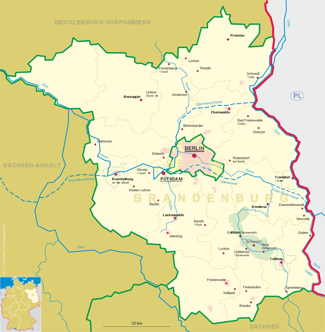
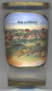 Jüterbog is situated at an elevation of 76 m in the Fläming hill range of southwestern Brandenburg.
The earliest written mention of Jutriboc (from Sorbic jutro, morning, and bog, god) dates from 1007. In 1157 the area was conquered by the archbishop of Magdeburg who thus created an exclave of his country between the possessions of the Askanian (later Brandenburg) and Wettin (later Saxony) dynasties. Jüterbog soon became a centre of trading. In 1174 it was chartered as a town, the second in Brandenburg. Because of its strong fortifications it was once nicknamed 'Märkisches Mantua'. The Thirty Years' War (1618–1648) caused a severe decline; after when Jüterbog passed to the Electorate of Saxony the town ultimately lost its former importance. The Seven Years' War (1756–1763) and the rise of Luckenwalde impoverished the town's craftsmen. In 1815, the northern half of the Electorate of Saxony, including Jüterbog, was awarded to Prussia by the Congress of Vienna. In 1823 Jüterbog became a garrison town, in 1841 it was connected to the railroad to Berlin. During World War II the town luckily suffered only little damages, a bomb raid in April 1945 spared the historic town centre.
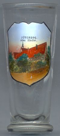
The  former Franciscan monastery [left, no. 1784]
was founded in 1480. The monastery church was finished in 1510. In 1540 the monastery was closed and the church
became a Protestant parish church. After 1966 the church was converted into a storehouse and began to fall into dereliction.
After a reconstruction in 1980–1985 it is now used as municipal library, theatre and concert hall.
former Franciscan monastery [left, no. 1784]
was founded in 1480. The monastery church was finished in 1510. In 1540 the monastery was closed and the church
became a Protestant parish church. After 1966 the church was converted into a storehouse and began to fall into dereliction.
After a reconstruction in 1980–1985 it is now used as municipal library, theatre and concert hall.
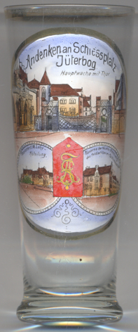
Glass no. 3102 [near left] is a souvenir from Schießplatz Jüterbog ('Shooting Range'), the military training area, founded here by the Prussian army in 1890. The artillery shooting school had been founded in 1867 and was originally located in Tegel (since 1920 part of Berlin). Upon the relocation of the school to Jüterbog, the school was divided into one for the field artillery (mounted atillery) and one for the 'foot' artillery. The school as such was closed with the end of World War I; however, the shooting range remained in use as a military training area. In 1934, the place was the largest military training area in Germany. The area was finally closed in 1992.
The pictures on the glass show:
Main Guard and Gate [top picture];
Barracks of the 3rd Teaching Division [bottom left picture];
Barracks of the 2nd Teaching Division of the Field Artillery Shooting School [bottom right picture].
[http://www.hl-barbara.de/index.php/die-garnison/kaiserliches-heer/artillerieschiessschulen,
http://www.lexikon-der-wehrmacht.de/Karte/Truppenubungsplatze/Jueterbog-R.htm,
http://www.deutschlandfunk.de/ein-truppenuebungsplatz-wird-zum-urwald.697.de.html?dram:article_id=74090]
![[scale]](lineal.jpg)