
|
|
| DEUTSCHLAND | GERMANY |
| Bundesland: Freistaat Sachsen | Saxony |
| Landkreis: Görlitz |
map →

 Zittau is situated at an elevation of 242 m on the river Mandau near its confluence with the river Neiße
in the Görlitz district in eastern Saxony at the border to Poland.
The municipality has a population of about 25,700 (2005).
Zittau is situated at an elevation of 242 m on the river Mandau near its confluence with the river Neiße
in the Görlitz district in eastern Saxony at the border to Poland.
The municipality has a population of about 25,700 (2005).
The oldest mention of Zittau is found in a document of 1238, a contract between the king of Bohemia and the Knights of St. John of Jerusalem in Prague where a man caled Henricus of Zittaus was listed as one of the witnesses. King Ottokar II II Přemysl of Bohemia visited Zittau in 1255 and determined its new boundaries by riding his horse around the town. At the same time Zittau was granted a town charter. Until the 14th century the town belonged to Bohemia. The town then joined the Upper Lausitz Union of towns which initiated its separation from Bohemia. Due to its location on the important trading route in the Neiße valley Zittau soon became a rich town. The Hussites conquered the town in 1424, and in 1538 the Reformation was introduced. After the Battle at the White Mountain (Bílá Hora, today part of Prague) (1620) during the Thirty Years' War (1618–1648) many Bohemian Protestants emigrated to Zittau. The Czech Protestant community existed in Zittau until the mid-19th century. In 1635 Zittau and the Upper Lausitz became part of Saxony. During the Seven Years' War (1756–1763) the town was set on fire by Austrian troops and large parts of the town were destroyed.
After the connection of Zittau to the railroad system in 1859 the town soon became a centre of machine and textile industry. During the Nazi era all of the Czech inhabitants of the Zittau region were forced to leave the country. At the end of World War II the river Neiße became the new border between Germany and Poland. Zittau thus lost its former borough of Großporitsch (Polish: Porajów).
The technical schools which were founded in Zittau after the war obtained the status of a technical university in 1988. In 2004 the central German, Czech and Polish celebrations of the expansion of the European Union took place in Zittau.
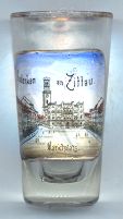
The picture on glass no. 1818 [above] shows the
 town
town
Pethau is situated at an elevation of 248 m west of the city centre of Zittau. The village has a population of 531 (2016) and is a city district of Zittau.
Petow was first mentioned in a document of 1391. While Pethau only had 109 inhabitants in 1834,
its population increased considerably at the end of the 19th and beginning of the 20th century due to
its industrialisation. Pethau was incorporated into the munnicipality of Zittau in 1970.
[https://de.wikipedia.org/wiki/Pethau]
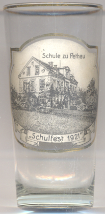
Glass no. 3216 is labeled Schule zu Pethau / Schulfest 1921 ('school at Pethau / school festival 1921').
Further glass in this collection produced as school festival souvenirs are from:
Burkersdorf (Burgstädt) and Waltersdorf.
![[scale]](lineal.jpg)