
|
|
| DEUTSCHLAND | GERMANY |
| Bundesland: Freistaat Sachsen | Saxony |
| Landkreis: Mittelsachsen |
map →

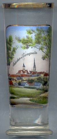 Geringswalde is situated at an elevation of 268 m between the rivers Mulde und Zschopau in Saxony.
The earliest mention of Geringswalde is found in a document of 1233 and refers to the foundation of a nunnery of the Benedictine monastery of Meißen. Five years later, the nunnery was approved by Pope Gregory IX. The nunnery existed some three centuries until it was dissolved during the Reformation. Until the mid-19th century linen weaving was the main source of income for the town. In the second half of the 19th century life changed completely. Even the last linen weavers who were left in the town had changed their occupation. Small industries, especially the production of looms, had now become the main oeconomical factor. Between 1889 and 1893 the railroad from Waldheim via Geringswalde to Rochlitz was constructed. In 1949 the neighbouring communities of Klostergeringswalde and Hilmsdorf were incorporated into Geringswalde; Aitzendorf and Dittmannsdorf followed in 1999.
The  town hall [background left]
was built in 1904–1905 in Neo-Renaissance and Art deco style and replaced the old town hall
which had been built in 1864. At the time of its construction the new town hall was thought by many to be
much too big for Geringswalde. The tower of the town hall has a height of 45 m.
town hall [background left]
was built in 1904–1905 in Neo-Renaissance and Art deco style and replaced the old town hall
which had been built in 1864. At the time of its construction the new town hall was thought by many to be
much too big for Geringswalde. The tower of the town hall has a height of 45 m.
The Martin Luther church [background right]
was built in 1888–1890 in Neo-Gothic style. The church replaced an older church that originally
was dedicated to Our Lady. A life-size crucifix of the 16th century and two baptismal fonts of around
1400 have remained from that old church.
![[scale]](lineal.jpg)