
|
|
| DEUTSCHLAND | GERMANY |
| Bundesland: Brandenburg | |
| Landkreis: Uckermark |
map →
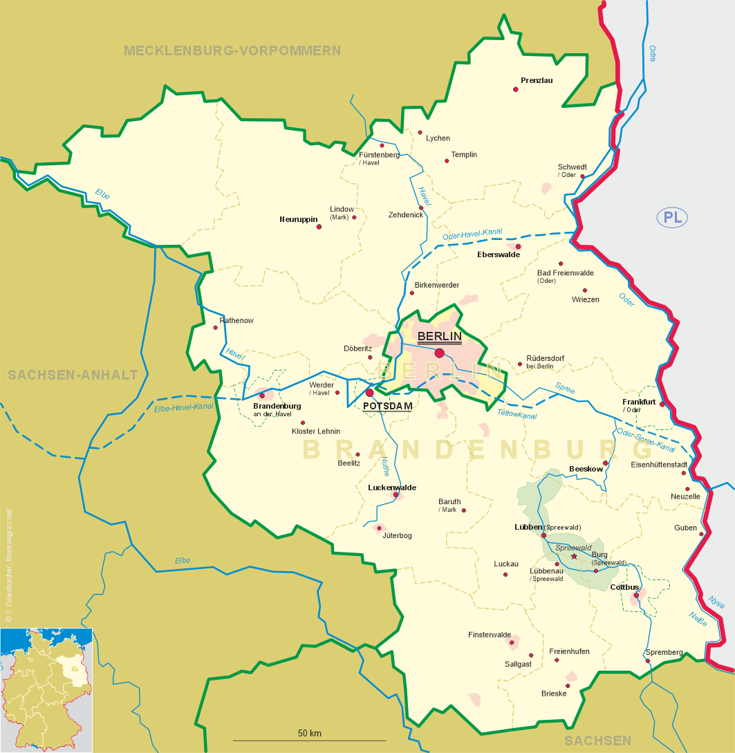
Templin is situated at an elevation of 60 m in the district Uckermark in the north of Germany's state of Brandenburg.
It is supposed that the name 'Templin' goes back to the Germanic word 'timpen', 'tempen' or 'tempel', which refers to a pointed hill; the ending '-lin' is of Slavic origin and refers to a location near water. The earliest written mention of Templyn dates from 1270. The oldest document known to have been issued in Templin itself, dates from 1287. A document of 1314 for the first time mentions the place as oppidum Templin, andthus refers to it as a town. After the death in 1319 of Margrave Waldemar, the last of the Brandenburg line of the Askanian dynasty, the Brandenburg region became the object of severe clashes between the other noble families, was devastated and impoverished. Most of Templin's fortifications of the late 13th and early 14th century are still preserved today. In 1379 Templin joined the union of Stralsund, Stettin (today Szczecin, Poland), Pasewalk, Prenzlau and Strasburg to protect itself from marauding gangs of bandits. After burgrave Friedrich VI of Nuremberg obtained the territory of Brandenburg (now Elector Friedrich I), Templin was the first town of the Uckermark region to render homage to the new sovereign in 1412. During the Thirty Years' War (1618–1648) Templin was hit hard by Danish and Swedish troops and also was repeatedly afflicted by the Plague. After the war only less than 10% of the former population were left. After a huge fire in 1735, which almost completely destroyed Templin, the whole town within the fortifications was rebuilt according to a regular ground plan. When the Finow canal was opened in 1745/1746, most of the trading activities were moved onto the waterway, which caused an economic decline for Templin.
The district Templin was formed in 1816, and one year later, Templin obtained the status of the district town. The upgrading in 1894/1895 of the Templin canal, which had already been built in 1744/1745, again stimulated trade and industry in Templin. Large parts of the town — about two thirds — were destroyed by bomb raids in 1944. In 1952 the district Templin was rearranged and the larger part became part of the new district Neubrandenburg. Templin remained the district town. After the reunification of Germany in 1990, the district Uckermark was formed in 1993 out of the former districts Angermünde, Prenzlau and Templin, and the non-county municipality of Schwedt. The seat of the district administration now is in Prenzlau.
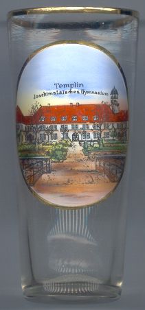
The  Joachimsthalsches Gymnasium [left] relocated from Berlin
to Templin in 1912. The school had been founded in Joachimsthal (district Barnim) in 1607 by Elector Joachim Friedrich of Brandenburg as an
elite school for the children of the nobility. In 1650 the school moved to Berlin. The last school building in Berlin
was constructed in 1880. After World War I the school lost its status of an independent noble foundation.
After World War II, the building was home to several different types of schools. The continuation
of its use as an educational institution after the reunification of Germany in 1990 failed due to financial reasons.
Joachimsthalsches Gymnasium [left] relocated from Berlin
to Templin in 1912. The school had been founded in Joachimsthal (district Barnim) in 1607 by Elector Joachim Friedrich of Brandenburg as an
elite school for the children of the nobility. In 1650 the school moved to Berlin. The last school building in Berlin
was constructed in 1880. After World War I the school lost its status of an independent noble foundation.
After World War II, the building was home to several different types of schools. The continuation
of its use as an educational institution after the reunification of Germany in 1990 failed due to financial reasons.
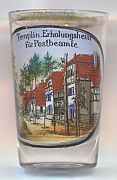
Glass no. 2189 [near left] shows a view of the
recreation
![[scale]](lineal.jpg)