
|
|
| ČESKÁ REPUBLIKA | CZECH REPUBLIC |
| Vysočina | Highlands (Jihlava) region |
| Okres: Žďár nad Sázavou |
map →
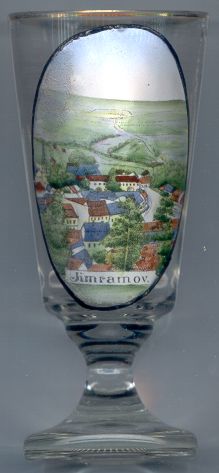 Jimramov is situated at an elevation of 495 m at the confluence of the rivers Svratka and Fryšávka
in the Žďár nad Sázavou district of the Vysočina region, directly at the
historic border between Bohemia and Moravia.
Jimramov is situated at an elevation of 495 m at the confluence of the rivers Svratka and Fryšávka
in the Žďár nad Sázavou district of the Vysočina region, directly at the
historic border between Bohemia and Moravia.
Jimramov was founded in the mid-13th century by the lords of Pernštejn. The oldest written document mentioning the place dates from 1361. The privileges granted to he lords of Pernštejn were confirmed in 1537. The historic old town centre was put under monumental protection in 1991.
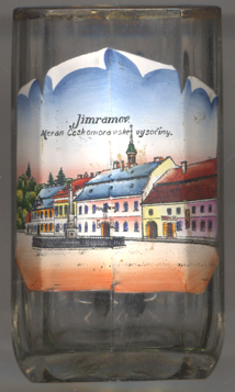 Glass no. 3094 [near left] is labeled Jimramov / Meran Českomoravské vysočiny
('Jimramov, the Meran of the Bohemian-Moravian highland', refering to Merano / Meran
in Alto Adige / South Tyrol, Italy).
Glass no. 3094 [near left] is labeled Jimramov / Meran Českomoravské vysočiny
('Jimramov, the Meran of the Bohemian-Moravian highland', refering to Merano / Meran
in Alto Adige / South Tyrol, Italy).
The  Town Hall is one of the oldest buildings of the town. It was built in 1589 after
a large fire had destroyed the town. The building received its present appearance in 1804 when it was rebuilt in Classicist style.
Town Hall is one of the oldest buildings of the town. It was built in 1589 after
a large fire had destroyed the town. The building received its present appearance in 1804 when it was rebuilt in Classicist style.
The monument depicted in the foreground is the
monument
[https://de.wikipedia.org/wiki/Jimramov, https://cs.wikipedia.org/wiki/Jimramov;
https://cs.wikipedia.org/wiki/Jimramovská_radnice;
https://www.vets.cz/vpm/mista/obec/1219-jimramov/]
![[scale]](lineal.jpg)