
|
|
| DEUTSCHLAND | GERMANY |
| Bundesland: Nordrhein-Westfalen | North Rhine-Westphalia |
| Regierungsbezirk: Münster | |
| Stadt: Gelsenkirchen |
map →
 Gelsenkirchen is situated at an elevation of 47 m in the Emscher river basin in the northern part of the Ruhr area.
The municipality is administered as a district in its own right in the administrative region Münster
of Germany's state of North Rhine-Westfalia. Gelsenkirchen has a population of about 275,000 (2006).
Gelsenkirchen is situated at an elevation of 47 m in the Emscher river basin in the northern part of the Ruhr area.
The municipality is administered as a district in its own right in the administrative region Münster
of Germany's state of North Rhine-Westfalia. Gelsenkirchen has a population of about 275,000 (2006).
The part of town now called Buer was first mentioned in a document as Puira in 1003. A few other parts of town which today lie in Gelsenkirchen's north end were mentioned in documents from the early Middle Ages, some examples being: Raedese (nowadays Resse), Middelvic (Middelich, today part of Resse), Sutheim (Sutum; today part of Beckhausen) and Sculven (nowadays Scholven). The oldest documents mentioning Gelstenkerken or Geilistirinkirkin date from 1150. Up until the middle of the 19th century, the area in and around Gelsenkirchen was only thinly settled and almost exclusively agrarian. In 1815, after temporarily belonging to the Grand Duchy of Berg, the land now comprising the city of Gelsenkirchen passed to Prussia, which assigned it to the province of Westphalia. After the discovery of coal – lovingly known as "Black Gold" – in the Ruhr area in 1840, and the subsequent industrialisation, the Cologne–Minden Railway and the Gelsenkirchen Main Railway Station were opened. In 1885, after the Bochum district was split up, Gelsenkirchen became the seat of its own district, which would last until 1926. In 1896, Gelsenkirchen was split away from Gelsenkirchen district to become an "independent city" (kreisfreie Stadt). In 1928, under the Prussian local government reforms, the cities of Gelsenkirchen and Buer along with the Amt of Horst together became a new kreisfreie Stadt called Gelsenkirchen-Buer. In 1930, on the city's advice, the city's name was changed to Gelsenkirchen. In the early 20th century Gelsenkirchen was the most important coal mining town in Europe. It was called the "city of a thousand fires", for all its smoking stacks. During the Nazi era Gelsenkirchen remained a centre of coal production and oil refining, and for this reason it was bombed by Allied air raids in World War II, which destroyed three fourths of Gelsenkirchen. The last coking plant shut down in 1999; in 2000 the last colliery closed and about there thousand coalminers lost their job. Today, Gelsenkirchen is a centre for sciences, services, and production.
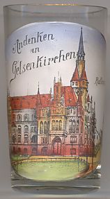
The picture on glass no. 2283 [above left] shows a view of the old
 town
town
![[scale]](lineal.jpg)