
|
|
| DEUTSCHLAND | GERMANY |
| Bundesland: Freistaat Sachsen | Saxony |
| Landkreis: Bautzen |
map →

Kamenz is situated at an elevation of 173 m in the Lausitz region of Germany's state of Saxony, about 25 km northwest of the district town Bautzen and about 36 km northeast of Saxony's capital, Dresden. The municipality has a population of about 16,900 (2025).
 At the location of today's old town a castle had been build at the end of the 12th century in order to secure the crossing of route
Via Regia and river Schwarze Elster. The Via Regia was an important trade route between Belgium and Silesia. In 1225 the town was
mentioned the first time and in 1319 it became an independent town. The League of six towns of Upper Lusatia ("Oberlausitzer Sechsstädtebund":
Bautzen, Zittau, Görlitz, Kamenz,
Löbau and Lauban (Lubań, PL)) was been founded in 1346 for protection against robber barons.
In 1707 a fire destroyed large parts of the old town. The philosopher and poet Gotthold Ephraim Lessing was born in Kamenz in 1729.
At the location of today's old town a castle had been build at the end of the 12th century in order to secure the crossing of route
Via Regia and river Schwarze Elster. The Via Regia was an important trade route between Belgium and Silesia. In 1225 the town was
mentioned the first time and in 1319 it became an independent town. The League of six towns of Upper Lusatia ("Oberlausitzer Sechsstädtebund":
Bautzen, Zittau, Görlitz, Kamenz,
Löbau and Lauban (Lubań, PL)) was been founded in 1346 for protection against robber barons.
In 1707 a fire destroyed large parts of the old town. The philosopher and poet Gotthold Ephraim Lessing was born in Kamenz in 1729.
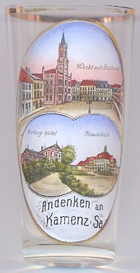
The  Town Hall [top picture] was built in 1848–1849 in Italian Renaissance revival style to
replace the previous town hall that had been destroyed by the large fire of 1842. The architect was Carl August Schramm.The imposing central
tower has a height of 40 metres.
Town Hall [top picture] was built in 1848–1849 in Italian Renaissance revival style to
replace the previous town hall that had been destroyed by the large fire of 1842. The architect was Carl August Schramm.The imposing central
tower has a height of 40 metres.
The bottom left picture on glass no. 2304 shows a view of the Hutberg-Hotel
The bottom right picture on the glass shows a view of the Realschule
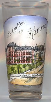
The picture on glass no. 2569 [near left] shows the
barracks
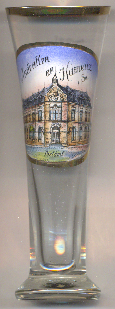
The historical post office [near left, no. 5035] was built in 1893. It was the first
building in Kamenz to be constructed using facing brickwork. In 1899, a telephone line was installed in the building. The post office was
extended in 1930. Since 2015, the building was owned by Deutsche Bank, but post office service continued until 2022.
[https://de.wikipedia.org/wiki/Kamenz;
https://de.wikipedia.org/wiki/Rathaus_Kamenz;
https://de.wikipedia.org/wiki/Hutberg_(Kamenz);
https://kamenz-entdecken.de/orte?q=Lessinggymnasium;
https://de.wikipedia.org/wiki/13._K%C3%B6niglich_S%C3%A4chsisches_Infanterie-Regiment_Nr._178;
https://kamenz-entdecken.de/orte?q=Postamt, https://www.alles-lausitz.de/postfiliale-in-kamenz-schliesst.html]
![[scale]](lineal.jpg)