
|
|
| DEUTSCHLAND | GERMANY |
| Bundesland: Baden-Württemberg | |
| Regierungsbezirk: Stuttgart | |
| Landkreis: Heilbronn |
map →

 Neckarsulm is situated at an elevation of 162 m where the river Sulm meets the Neckar. The municipality has a population of about 26,600 (2009)
and thus is the largest city of the district Heilbronn.
Neckarsulm is situated at an elevation of 162 m where the river Sulm meets the Neckar. The municipality has a population of about 26,600 (2009)
and thus is the largest city of the district Heilbronn.
Villa Sulmana was first mentioned in AD 771 in a deed of donation of the Lorsch Codex. At first, the town was in possession of the lords of Weinsberg. Around 1300 Neckarsulm obtained the status as a town and market place. In 1335 the town was sold to the archbishops of Mainz and in 1484 it finally came in possession the Teutonic Knights who remained in possession of the town for over 300 years. During the course of the 17th century, the modern name Neckarsulm replaced Sulm, Solme and Sulmana which had been in use until then. After the Napoleonic Wars, Neckarsulm became part of the Kingdom of Württemberg in 1805/1806.
The  castle of the Teutonic Order [left]
is located in the southwestern corner of the old town fortifications.
Its origins presumably go back to the 13th century.
After the destruction of the castle on the nearby Scheuerberg during the Pesants' War of 1525, the Teutonc Order moved its seat to this place.
In 1945 large parts of the castle where destroyed by fire after an Allied bomb raid on 2 April.
In 1949 the damaged parts were restored.
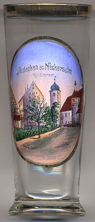
The picture on glass no. 2609 shows a view of
the so-called Bandhaus [far left, barely visible], which originally was used as a storehouse,
the Amsthaus, the keep (the lower parts of which date from the 13th century; the keep is depicted with its Baroque onion dome of 1772, which was replaced by a simple roof after World War II),
and the chapel [far right, barely visible], built in 1487.
castle of the Teutonic Order [left]
is located in the southwestern corner of the old town fortifications.
Its origins presumably go back to the 13th century.
After the destruction of the castle on the nearby Scheuerberg during the Pesants' War of 1525, the Teutonc Order moved its seat to this place.
In 1945 large parts of the castle where destroyed by fire after an Allied bomb raid on 2 April.
In 1949 the damaged parts were restored.
The picture on glass no. 2609 shows a view of
the so-called Bandhaus [far left, barely visible], which originally was used as a storehouse,
the Amsthaus, the keep (the lower parts of which date from the 13th century; the keep is depicted with its Baroque onion dome of 1772, which was replaced by a simple roof after World War II),
and the chapel [far right, barely visible], built in 1487.
![[scale]](lineal.jpg)