
|
|
| ÖSTERREICH | AUSTRIA |
| Bundesland: Niederösterreich | Lower Austria |
| Bezirk: Hollabrunn |
map →

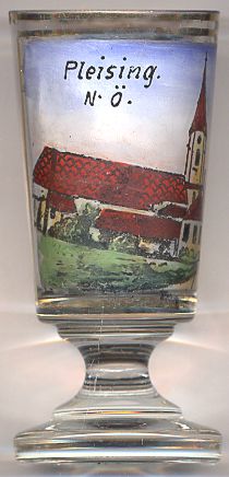
 Pleissing is situated at an elevation of 421 m about 6 km south of Hardegg in the north of Lower Austria.
Pleissing (spelled incorrectly on the glass with one s only) is one of the ten cadastral districts of the municipality of Hardegg and is the
seat of the municipal administration.
Pleissing is situated at an elevation of 421 m about 6 km south of Hardegg in the north of Lower Austria.
Pleissing (spelled incorrectly on the glass with one s only) is one of the ten cadastral districts of the municipality of Hardegg and is the
seat of the municipal administration.
The  parish church Sankt Kunigunde [left]
goes back to a prior, Gothic, church of which the chancel has remained. The remaining parts of the present church were built in 1757 in Baroque style.
The parish church is currently taken care of by parish of Weitersfeld.
parish church Sankt Kunigunde [left]
goes back to a prior, Gothic, church of which the chancel has remained. The remaining parts of the present church were built in 1757 in Baroque style.
The parish church is currently taken care of by parish of Weitersfeld.
[http://www.dsp.at/pfarren/pfarrinfo.php?links=Pleissing; https://de.wikipedia.org/wiki/Benutzer:Karl_Gruber/Kulturdenkm%C3%A4ler_in_Hardegg#Pleissing]
![[scale]](lineal.jpg)