
|
|
| DEUTSCHLAND | GERMANY |
| Bundesland: Freistaat Bayern | Bavaria |
| Regierungsbezirk: Schwaben | |
| Landkreis: Oberallgäu |
map →

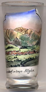 Oberstdorf is situated at an elevation of 813 m in the Allgäu Alps of southern Bavaria. The municipality covers an area of 320 km² and thus is Bavaria's third-largest
municipality (in terms of area) after Munich and Lenggries. The municiplity has a population of about 9,900 (2011). About 17km southwest of Oberstdorf's
centre, the pass Haldenwanger Eck (1,931 m) marks Germany's southernmost point. Oberstdorf is recognised as a climatic and hydrotherapeutic spa. In addition, the surrounding
mountains are a popular climbing destination for tourists.
Oberstdorf is situated at an elevation of 813 m in the Allgäu Alps of southern Bavaria. The municipality covers an area of 320 km² and thus is Bavaria's third-largest
municipality (in terms of area) after Munich and Lenggries. The municiplity has a population of about 9,900 (2011). About 17km southwest of Oberstdorf's
centre, the pass Haldenwanger Eck (1,931 m) marks Germany's southernmost point. Oberstdorf is recognised as a climatic and hydrotherapeutic spa. In addition, the surrounding
mountains are a popular climbing destination for tourists.
Oberstdorf was mentioned in a written document for the first time in 1141. The local domains were purchased by the monastery of Augsburg in 1440.
In 1495 Oberstdorf obtained the status of a market town. The sulfur spring in Tiefenbach was used already in the 16th/17th century.
The famous ski jump on the Schattenberg was opened in 1926 and since 1962 is part of the Vierschanzentournee (Four Hills Tournament).
Oberstdorf also hosts the annual Nebelhorn Trophy figure skating competition and has hosted the German Figure Skating Championships twelve times. It has also hosted the
1982, 2000, and 2007 World Junior Figure Skating Championships.
In 1972 the former municipalities of Tiefenbach bei Oberstdorf and Schöllang (with Schöllang, Reichenbach and Rubi) were incorporated into the municipality of Oberstdorf.
[https://de.wikipedia.org/wiki/Oberstdorf, http://en.wikipedia.org/wiki/Oberstdorf]
![[scale]](lineal.jpg)