
|
|
| DEUTSCHLAND | GERMANY |
| Bundesland: Baden-Württemberg | |
| Regierungsbezirk: Stuttgart | |
| Landkreis: Ostalbkreis |
map →

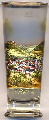 Heubach is situated at an elevation of 466 m in the Rems valley at the foot of the Rosenstein mountain (part of the Swabian Jura)
about halfway between Schwäbisch Gmünd and Aalen. The municipality has a population of about 10,000 (2011).
Heubach is situated at an elevation of 466 m in the Rems valley at the foot of the Rosenstein mountain (part of the Swabian Jura)
about halfway between Schwäbisch Gmünd and Aalen. The municipality has a population of about 10,000 (2011).
The earliest written document which mentins Hôbach dates from 1234. Towards the end of the 13th century it came in poassession of the
counts of Oettingen who pawned of the village to the counts of Württemberg in 1358. The privileges of a town were given to Heubach in 1334.
In 1579 Heubach became a local administrative seat owithin the duchy of Württemberg. In the 18th century, Heubach was made the capital of the district
Heubach, which in 1807 was merged with the district Gmünd. In 1938 the district Gmünd was renamed Landkreis Schwäbisch Gmünd. Most parts of this district
were merged with the district Aalen in 1973 and the new district was named Ostalbkreis. In 1971 the neighbouring community of Lautern
was incorporated into the municipality of Heubach.
[https://de.wikipedia.org/wiki/Heubach]
![[scale]](lineal.jpg)