
|
|
| DEUTSCHLAND | GERMANY |
| Bundesland: Freistaat Bayern | Bavaria |
| Regierungsbezirk: Oberbayern | |
| Landkreis: Unterallgäu |
map →

 Erkheim is situated at an elevation of 598 m in the district Unterallgäu, about 15 km east of the city of
Memmingen. The municipality has a population of about 2,900 (2014).
Erkheim is situated at an elevation of 598 m in the district Unterallgäu, about 15 km east of the city of
Memmingen. The municipality has a population of about 2,900 (2014).
The earliest written document mentioning Erkheim date from 764, a further document mentioning the place in a more detailed fashion dates from 1176. Until 1803 the domains of Erkheim were divided between the monastery of Ottobeuren (three quarters) and the Unterhospital of Memmingen (one quarter). Following the mediatisation of Germany (Reichsdeputationshauptschluss of 1803), Erkheim became part of Bavaria. Until the administrative reform of 1972 Erkheim was part of the district Memmingen, thereafter it was part of the district Mindelheim, which in 1973 was renamed ditrict Unterallgäu. The formerly independent municipalities of Arlesried and Daxberg were incorporated into Erkheim in 1972, Schlegelsberg followed in 1978.
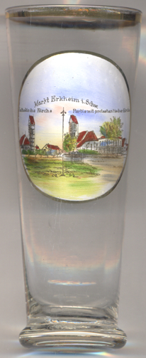
The  Catholic parish church Mariä Himmelfahrt (Ascension of Our Lady) [left]
goes back to a church dating from between 1447 and 1500 of which the church tower remains. The remaining parts of the church
were rebuilt in the late 17th century (dedicated in 1697). A modern part was added at the western end in 1930.
Catholic parish church Mariä Himmelfahrt (Ascension of Our Lady) [left]
goes back to a church dating from between 1447 and 1500 of which the church tower remains. The remaining parts of the church
were rebuilt in the late 17th century (dedicated in 1697). A modern part was added at the western end in 1930.
The Protestant (Lutheran) church Sankt Peter und Paul [right]
was first mentioned in 1167. The lower parts of the church tower seem to remain from this church.
A new church was built in 1433. The roof structure and the ceiling of the church were rebuilt in 1803–1807.
[https://de.wikipedia.org/wiki/Erkheim;
https://de.wikipedia.org/wiki/Mariä_Himmelfahrt_(Erkheim);
https://de.wikipedia.org/wiki/St._Peter_und_Paul_(Erkheim)]
![[scale]](lineal.jpg)