
|
|
| DEUTSCHLAND | GERMANY |
| Bundesland: Freistaat Bayern | Bavaria |
| Regierungsbezirk: Schwaben | |
| Landkreis: Unterallgäu |
map →

Memmingen is situated at an elevation of 601 m near the western border of Bavaria to Baden-Württemberg, about 50 km south of Ulm and 115 km southwest of Munich. Culturally and art-historically Memmingen is part of Upper Swabia; due to its closeness to the Allgäu region is also frequently named 'Gateway to the Allgäu'. The municipality, administratively an urban district, has a population of about 41,600 (2012).
It is believed that on the site of present day Memmingen in Roman times there was a small military town, probably called Cassiliacum. In the 5th century an
Alemannic settlement was established and in the 7th century there was here a palace belonging to the king of the Franks. Memmingen was linked to Bohemia, Austria and Munich
by a trading route ('salt road') to Lindau. Another important route through Memmingen was the 'Italian road' from Northern Germany to Switzerland and Italy.
Both roads helped Memmingen gain importance as a trading centre. The earliest known written mention of Mammingin is dates from 1128, a document from the monastery
Ochsenhausen. In 1158 Memmingen was chartered as a town and in 1286 it became an Imperial City, thus being immediate to the Emperor. During the Protestant Reformation
in the 16th century, Memmingen first followed the Tetrapolitan Confession (1530; named for the cities Strasbourg, Konstanz,
Memmingen and Lindau) and later (1531) the Augsburg confession. In the 1630s Memmingen was at centre stage during the Thirty Years' War
(1618–1648), and the Imperial generalissimo Wallenstein was quartered in the town when he was dramatically dismissed from service. Following the reorganization of Germany
following the Reichsdeputationshauptschluss in 1802, Memmingen became part of Bavaria.
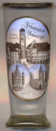
The  Martinsturm [left, no. 2864: top picture: background] is the bell-tower of the city parish
church Sankt Martin, the main church of the Evangelical-Lutheran church district Memmingen.
The history of the church can be traced by to the 9th century. The present church was begun around 1325 and was completed around 1500.
The carved wood choir seating dates from 1501–1507 and counts as one of the most magnificent exampes of its kind from the late Gothic period in Germany
(together with those from the minster churches of Ulm and Konstanz).
The lower parts of the church tower date from around 1325, although an ealier tower must have been built already around 1300. The upper sections of the tower
were added around 1405. At first, the tower was topped by a high wooden steeple, which, however, was destroyed by lightning in 1535.
Two years later, in 1537, the destroyed steeple was replaced by the present octogonal tower section topped by a copper-covered helmed roof.
Since then, the tower has a height of 66 metres. Since its construction, the lower parts of the tower belonged to the church congregation, while the
upper part belonged to the city. The city transfered its property rights to the parish in 1927.
Martinsturm [left, no. 2864: top picture: background] is the bell-tower of the city parish
church Sankt Martin, the main church of the Evangelical-Lutheran church district Memmingen.
The history of the church can be traced by to the 9th century. The present church was begun around 1325 and was completed around 1500.
The carved wood choir seating dates from 1501–1507 and counts as one of the most magnificent exampes of its kind from the late Gothic period in Germany
(together with those from the minster churches of Ulm and Konstanz).
The lower parts of the church tower date from around 1325, although an ealier tower must have been built already around 1300. The upper sections of the tower
were added around 1405. At first, the tower was topped by a high wooden steeple, which, however, was destroyed by lightning in 1535.
Two years later, in 1537, the destroyed steeple was replaced by the present octogonal tower section topped by a copper-covered helmed roof.
Since then, the tower has a height of 66 metres. Since its construction, the lower parts of the tower belonged to the church congregation, while the
upper part belonged to the city. The city transfered its property rights to the parish in 1927.
The Town Hall [left, no. 2864: bottom left picture] on the northern end of the market square dates
from the 16th century and is one of the most important and best-known historical buildings of Memmingen.
The oldest mentions of a town hall date from the 14th century. The old building was enlarged in 1488 by adding additional floors, and further enlargements followed
later (e.g. in 1522). The present building was planned presumably in 1565 as in that year part of the neighbouring building was broken down. The construction of
the new town hall, however, was only carried out in 1589. In the 18th century, the town hall was remodeled in Rococo style, the characteristic gable was constructed
in 1764–1765.
The Kempter Tor (Kempten Gate) [left, no. 2864: bottom right picture] is located on the southern edge
of the historic old town and was part of the former town fortifications of the late 14th century. The gate formed the southern exit of the town and is named for the city of Kempten,
about 35 km southeast of Memmingen. As in the course of history Memmingen was usually attacked from the west, the gate tower never was destroyed.
Plans to remove the gate tower in 1863 did not gain the permission of the district government in Augsburg, so that only a small second
gateway was constructed to one side of the tower; a second additional small gateway was constructed on the other side of the tower in 1893.
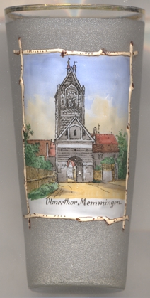 The Ulmer Tor (Ulm Gate) [near left, no. 4087] is located on the northern end of the 'Ulmer
Vorstadt', the suburb towards Ulm. A small part of the battlement as part of the town's historic fortifications still exists
next to the gate. The Ulm suburb began to develop around 1400 and on its northern side, this gate was part of the new town wall. The gate tower was only
finished in 1445. The wooden gate doors and the drawbridge were removed in 1821.
The Ulmer Tor (Ulm Gate) [near left, no. 4087] is located on the northern end of the 'Ulmer
Vorstadt', the suburb towards Ulm. A small part of the battlement as part of the town's historic fortifications still exists
next to the gate. The Ulm suburb began to develop around 1400 and on its northern side, this gate was part of the new town wall. The gate tower was only
finished in 1445. The wooden gate doors and the drawbridge were removed in 1821.
[http://en.wikipedia.org/wiki/Memmingen, https://de.wikipedia.org/wiki/Memmingen;
https://de.wikipedia.org/wiki/St._Martin_(Memmingen);
https://de.wikipedia.org/wiki/Rathaus_(Memmingen);
https://de.wikipedia.org/wiki/Kempter_Tor;
https://de.wikipedia.org/wiki/Ulmer_Tor]
![[scale]](lineal.jpg)