
|
|
| ÖSTERREICH | AUSTRIA |
| Bundesland: Steiermark | Styria |
| Bezirk: Hartberg-Fürstenfeld |
map →

 Sinnersdorf is situated at an elevation of 508 m on the river Pinka, about 6 km southeast of
Pinggau in eastern Styria directly at the border to the Austrian province of Burgenland.
Sinnersdorf has a population of 257 (2011).
Sinnersdorf is situated at an elevation of 508 m on the river Pinka, about 6 km southeast of
Pinggau in eastern Styria directly at the border to the Austrian province of Burgenland.
Sinnersdorf has a population of 257 (2011).
The earliest document mentioning the place dates from 1338. The name already in the 14th century changed from
Syndramsdroh, Syndarmansdorf to Sündersdorf and to the modern form.
Sinnersdorf was already part of the municipality of Pinggau, Styria, at the time of
the municipality's creation in 1849. Although being part of the municipality of Pinggau, Sinnersdorf almost entirely
is surrounded by the municipality of Pinkafeld (Burgenland) to the west, south and east
(at that time still part of the kingdom of Hungary within the Austro-Hungarian monarchy).
The railway line from
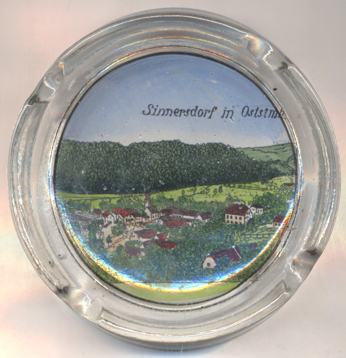
The  church of St. Patrizius, St. Donatus and St. Florian
[centre, barely visible] was built in 1756. The church was enlarged in 1955 and was renovated in
1977/78 and in 1997. It is an independent local pastoral care unit of the Roman-Catholic parish of Pinkafeld.
church of St. Patrizius, St. Donatus and St. Florian
[centre, barely visible] was built in 1756. The church was enlarged in 1955 and was renovated in
1977/78 and in 1997. It is an independent local pastoral care unit of the Roman-Catholic parish of Pinkafeld.
[https://de.wikipedia.org/wiki/Sinnersdorf_(Gemeinde_Pinggau); http://www.fallingrain.com/world/AU/06/Sinnersdorf.html;
https://de.wikipedia.org/wiki/Pinkatalbahn;
http://www.dade.at/pinkafeld-kirche/hist-rk.html, http://www.martinus.at/adressbuch/pfarre/38121042008143504.html]
![[scale]](lineal.jpg)