
|
|
| DEUTSCHLAND | GERMANY |
| Bundesland: Freistaat Bayern | Bavaria |
| Regierungsbezirk: Unterfranken | |
| Landkreis: Kitzingen |
map →

 Kitzingen is situated at an elevation of 205 m at the river Main west of the Steigerwald mountains in Lower Franconia,
about 20 km east of the regions's capital, Würzburg.
Kitzingen is the administrative seat of the district of the same name. The municipalitiy has a population of about
20,800 (2017).
Kitzingen is situated at an elevation of 205 m at the river Main west of the Steigerwald mountains in Lower Franconia,
about 20 km east of the regions's capital, Würzburg.
Kitzingen is the administrative seat of the district of the same name. The municipalitiy has a population of about
20,800 (2017).
According to legend, Kitzingen was founded when the Countess of Schwanberg lost her jeweled scarf while standing on the ramparts of her castle. The castle was located high above the fertile section of the Main River Valley where Kitzingen now lies. The Countess promised to build a cloister on the spot where the scarf was found. When it was found by a shepherd named Kitz, she kept her word and built a cloister which she called Kitzingen. That Benedictine cloister, founded in the 8th century on the site of the present town of Kitzingen, defended the ford across the Main River. Kitzingen's history is closely tied to Würzburg. Kitzingen became a free imperial city around the year 1000. During the next century the town changed rulers often, mostly being ruled by Würzburg prince-bishops who sold the town twice to fill their empty treasury. After the Pesants' Revolt in 1525, Protestantism was abolished by the prince-bishops and more then 1,000 residents were forced to leave the town. However, The episcopal Edict of Toleration of 1650 encouraged the return of exiled Protestants. During the 18th century, Kitzingen flourished as one of the most important ports on the Main river. The Congress of Vienna (1814) confirmed the end of the episcopal rule and transfered Kitzingen to the Kingdom of Bavaria. After World War II, uring the Cold War period, Kitzingen was a staging area for the U.S. European Command's air defenses against possible Soviet air and nuclear attack. The last U.S. personnel left Kitzingen in 2007.
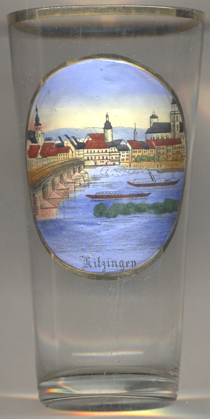
The  Old Main Bridge [left] spans the river Main between the old town and
the town quarter Etwashausen. The earliest writen mention of a (wooden) bridge dates back to 1300. During the ensuing
centuries, the bridges was replaced by an arched stone bridge. In 1945, German army units blew up two arches of the bridge.
After the war, the reconstruction was completed in 1948. The three cenral arches of the bridge were replaced in
1955–1956 by a single beam bridge in order to allow the passing of larger ships.
Old Main Bridge [left] spans the river Main between the old town and
the town quarter Etwashausen. The earliest writen mention of a (wooden) bridge dates back to 1300. During the ensuing
centuries, the bridges was replaced by an arched stone bridge. In 1945, German army units blew up two arches of the bridge.
After the war, the reconstruction was completed in 1948. The three cenral arches of the bridge were replaced in
1955–1956 by a single beam bridge in order to allow the passing of larger ships.
[https://en.wikipedia.org/wiki/Kitzingen, https://de.wikipedia.org/wiki/Kitzingen;
https://de.wikipedia.org/wiki/Alte_Mainbrücke_Kitzingen]
![[scale]](lineal.jpg)