
|
|
| DEUTSCHLAND | GERMANY |
| Bundesland: Niedersachsen | Lower Saxony |
| Landkreis: Oldenburg |
map →
 Harpstedt is situated at an elevation of 35 m in the heart of the Wildeshauer Geest nature reserve in the
Oldenburg region, about 17 km south of Delmenhorst and
12 km east of Wildeshausen. The municipality has a population of about 4,700 (2015). Harpstedt is also the administrative
seat of the Samtgemeinde ("collective municipality") Harpstedt, which also administers Beckeln, Colnrade, Dünsen,
Groß Ippener, Kirchseelte, Prinzhöfte and Winkelsett.
Harpstedt is situated at an elevation of 35 m in the heart of the Wildeshauer Geest nature reserve in the
Oldenburg region, about 17 km south of Delmenhorst and
12 km east of Wildeshausen. The municipality has a population of about 4,700 (2015). Harpstedt is also the administrative
seat of the Samtgemeinde ("collective municipality") Harpstedt, which also administers Beckeln, Colnrade, Dünsen,
Groß Ippener, Kirchseelte, Prinzhöfte and Winkelsett.
Harpenstede was first mentioned in a written document of 1203. In 1396 the village obtained town privileges according to the Bremen town law. In the 20th century, Harpstedt was part of the district Hoya until 1977 when it was reallocated to the district Oldenburg.
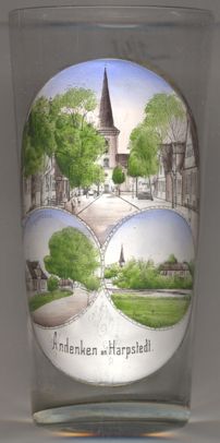
The Protestant  Christuskirche [top picture] was built in 1742–1753.
The bottom left picture on glass no. 3323 is labeled
Burgstraße
[https://de.wikipedia.org/wiki/Harpstedt, https://en.wikipedia.org/wiki/Harpstedt;
https://de.wikipedia.org/wiki/Samtgemeinde_Harpstedt;
https://de.wikipedia.org/wiki/Christuskirche_(Harpstedt)]
![[scale]](lineal.jpg)