
|
|
| DEUTSCHLAND | GERMANY |
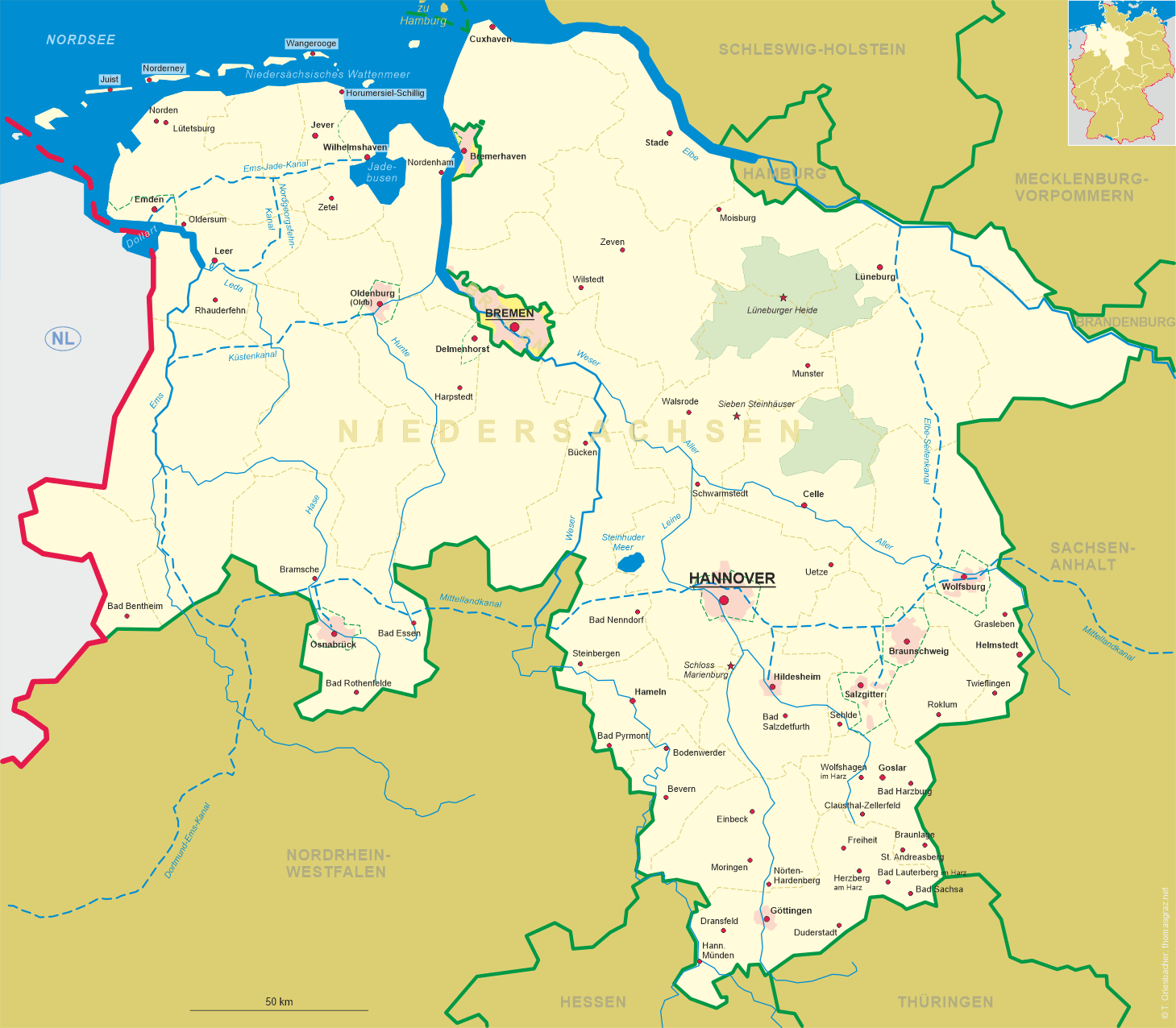
| Bundesland: Niedersachsen | Lower Saxony |
| Stadt: Delmenhorst |
map →
 Delmenhorst is situated at an elevation of 8 m on the river Delme immediately southwest of the city of Bremen.
The city has a population of about 75,000 (2008).
Delmenhorst is situated at an elevation of 8 m on the river Delme immediately southwest of the city of Bremen.
The city has a population of about 75,000 (2008).
Delmenhorst was first mentioned in a charter in the year 1254, after the Count of Oldenburg, Otto I, bought the place near the river Delme in 1234.
A castle to protect the newly founded settlement was established in about 1247. The following count, Otto II, made the castle his residency; Delmenhorst
was declared an independent town on 15 July 1371 under Bremen's law.
After a short period under the governance of the bishop of Bremen from 1421 to 1436 Delmenhorst returned under the custody of Oldenburg.
Its reign ended in 1482 thanks to a siege laid to the castle under the leadership of the bishop of
Münster. Therefore the town now was under Münster authority until finally count Anton I won back the town as well as the castle in 1547.
When the last heir of Anton, Christian, died in 1647, Delmenhorst again fell under Oldenburg custody. As the Oldenburg regent of that time was a relative of the
Danish king, Delmenhorst was under Danish control now.
 From 1667 until 1773 the counties of Oldenburg and Delmenhorst were ruled by the Danish Kings in personal union;
between 1711 and 1731 Delmenhorst was pawned off to the dukes of Braunschweig-Lüneburg.
In 1806 a French and Dutch army occupied the territory; Delmenhorst was a part of the French empire from 1811 to 1813.
In 1815 the duchy of Oldenburg with Delmenhorst became the grand duchy of Oldenburg.
In the industrial age Delmenhorst experienced a great economical growth, thanks to Bremen. Since Bremen was in a different duty zone, merchants who wanted
to export manufactured goods outside of Bremen had to pay high customs duties. They therefore only exported the resources and produced their commodities in the
surrounding villages. The number of inhabitants quadrupled in these years.
In 1903 Delmenhorst was declared kreisfrei, meaning it was under its own regentship, not having to obey any other county.
After World War II Delmenhorst was in the British zone of occupation and had to deal with thousands of refugees from Eastern Germany.
In 1946 the states of Oldenburg, Hannover, Braunschweig and Schaumburg-Lippe were merged into the new state of Lower Saxony.
In the year 2000 Delmenhorst was an outpost of the Hannover-based Expo 2000.
From 1667 until 1773 the counties of Oldenburg and Delmenhorst were ruled by the Danish Kings in personal union;
between 1711 and 1731 Delmenhorst was pawned off to the dukes of Braunschweig-Lüneburg.
In 1806 a French and Dutch army occupied the territory; Delmenhorst was a part of the French empire from 1811 to 1813.
In 1815 the duchy of Oldenburg with Delmenhorst became the grand duchy of Oldenburg.
In the industrial age Delmenhorst experienced a great economical growth, thanks to Bremen. Since Bremen was in a different duty zone, merchants who wanted
to export manufactured goods outside of Bremen had to pay high customs duties. They therefore only exported the resources and produced their commodities in the
surrounding villages. The number of inhabitants quadrupled in these years.
In 1903 Delmenhorst was declared kreisfrei, meaning it was under its own regentship, not having to obey any other county.
After World War II Delmenhorst was in the British zone of occupation and had to deal with thousands of refugees from Eastern Germany.
In 1946 the states of Oldenburg, Hannover, Braunschweig and Schaumburg-Lippe were merged into the new state of Lower Saxony.
In the year 2000 Delmenhorst was an outpost of the Hannover-based Expo 2000.
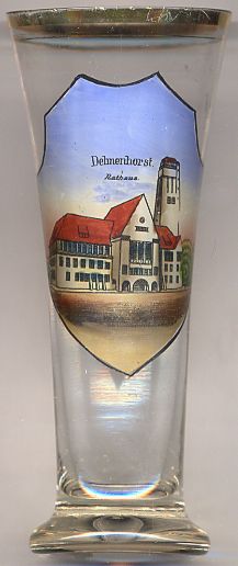
The landmark of the town is complex of the
 watertower Town Hall,
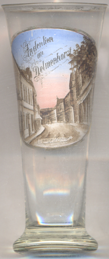
Glass no. 3615 [right] shows a view of Lange Straße ('Long
Street'), the main street traversing Delmenhorst passing the market square on its northern side.
[Texts adapted from http://en.wikipedia.org/wiki/Delmenhorst, https://de.wikipedia.org/wiki/Delmenhorst;
https://de.wikipedia.org/wiki/Rathaus_Delmenhorst]
![[scale]](lineal.jpg)