
|
|
| ČESKÁ REPUBLIKA | CZECH REPUBLIC |
| Středočeský kraj | Central Bohemia region |
| Okres: Příbram |
map →
 Hvožďany is situated at an elevation of 533 m about 9 km southwest of
Rožmitál pod Třemšínem and 11 km west
of Březnice in the southwestern corner of the district
Příbram. The municipality of Hvožďany has a population of about
777 (2018) and also includes the villages of Leletice, Planiny, Pozdyně, Roželov and Vacíkov.
Hvožďany is situated at an elevation of 533 m about 9 km southwest of
Rožmitál pod Třemšínem and 11 km west
of Březnice in the southwestern corner of the district
Příbram. The municipality of Hvožďany has a population of about
777 (2018) and also includes the villages of Leletice, Planiny, Pozdyně, Roželov and Vacíkov.
The first written mention of the village dates back to 1352. At that time there was already a Gothic church dedicated to St. Prokop and a fortress which was destroyed at the turn of the 15th and 16th centuries. A new, larger castle was built in its place. This Renaissance building was mentioned first in 1542. After the abolition of manorialism in 1848, the municipality Hvožďany was created. Over time, it belonged to the political districts Březnice (1850), Blatná (1868), Strakonice (1942), Blatná (1945), and finally Příbram (1960).
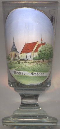
The  church of the Visitiation of Our Lady and of St. Prokop [left]
dates back to the 14th century. The interior decorations mostly date from the Baroque period. Ceiling paintings
were added in 1932.
church of the Visitiation of Our Lady and of St. Prokop [left]
dates back to the 14th century. The interior decorations mostly date from the Baroque period. Ceiling paintings
were added in 1932.
The Baroque bell tower [far left] was built in 1691 replacing an
older, wooden structure. The original shingle roof of the bell tower was replaced by copper shee during a
renovation in 2001.
[https://cs.wikipedia.org/wiki/Hvožďany_(okres_Příbram),
https://www.mistopisy.cz/pruvodce/obec/8162/hvozdany/historie/
http://genealogie.nka.cz/nemecke-nazvy-obci.html;
https://www.hvozdany.cz/obec-1/informace-o-obci-1/historicke-stavby-a-pamatky-/goticky-kostel-sv-prokopa-a-navstiveni-panny-marie-ve-hvozdanech/]
![[scale]](lineal.jpg)