
|
|
| DEUTSCHLAND | GERMANY |
| Bundesland: Freistaat Bayern | Bavaria |
| Regierungsbezirk: Unterfranken | |
| Landkreis: Miltenberg |
map →

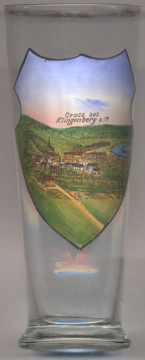
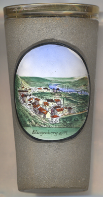 Klingenberg am Main (official name: Klingenberg a. Main) is situated at an elevation of
128 m on the river Main about 12 km northwest of the district town Miltenberg in
the extreme west of Bavaria's administrative region Lower Franconia. The municipality, which includes also the villages of
Trennfurt and Röllfeld, has a population of about 6,100 (2017).
Klingenberg am Main (official name: Klingenberg a. Main) is situated at an elevation of
128 m on the river Main about 12 km northwest of the district town Miltenberg in
the extreme west of Bavaria's administrative region Lower Franconia. The municipality, which includes also the villages of
Trennfurt and Röllfeld, has a population of about 6,100 (2017).
In the 2nd century, the Romans built the border fortifications of the Limes Germanicus through Germany, which ran along
the Trennfurt side of the Main. In 1100, a nobleman named Heinrich named himself after the old castle Clingenburg.
The village Clingenburg was founded around 1170. In 1500, town and castle passed to the archbishops of Mainz.
In 1552, the old town was completely destroyed, like so many others, the margrave of Brandenburg-Kulmbach
during the Second Margrave War. Clingenburg castle was destroyed by the French in the late 17th century and was never rebuilt.
After the dissolution of the Archbishopric of Mainz in the course of the 1803 Reichsdeputationshauptschluss,
Klingenberg at first belonged to the newly formed Principality of Aschaffenburg, which was
swallowed in 1810 by the Grand Duchy of Frankfurt. After the Congress of Vienna (1815), Klingenberg,
along with the entire Aschaffenburg-Miltenberg region and the Grand Duchy of Würzburg (the
successor state to the old Prince-Bishopric of Würzburg) passed to the Kingdom of Bavaria. The neighbouring villages of
Trennfurt and Röllfeld were incorprated into Klingenberg in 1976.
[https://de.wikipedia.org/wiki/Klingenberg_am_Main, https://en.wikipedia.org/wiki/Klingenberg_am_Main]
![[scale]](lineal.jpg)