
|
|
| POLSKA | POLAND |
| województwo: Śląskie | voivodship: Silesia |
| powiat: Tarnowskie Góry | county: Tarnowskie Góry |
map →
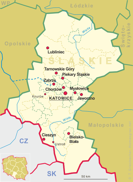
Tarnowskie Góry (in German: Tarnowitz) is situated at an elevation of 320 m in the Silesian Highlands, about 25 km northwest of Katowice. On the south, it borders the Upper Silesian metropolitan area of southern Poland and northeast Czech Republic, centered on the cities of Katowice (Poland) and Ostrava (Czech Silesia). The municipality of Tarnowskie Góry has a population of about 61,400 (2019) and consists of (former German names in italics) Bobrowniki Śląskie-Piekary Rudne (Bobrownik-Rudy Piekar), Lasowice (Lassowitz), Opatowice (Opattowitz), Osada Jana (Galgenberg), Pniowiec (Pniowitz), Repty Śląskie (Repten), Rybna (Rybna), Sowice (Sowitz), Stare Tarnowice (Alt Tarnowitz), Strzybnica (Friedrichshütte) and Śródmieście-Centrum (the historical town centre).
 The earliest settlements around Tarnowskie Góry date back to over 20 thousand years BC. Repty Śląskie, now
within Tarnowskie Góry's town limits, was mentioned in an official papal document dating from 1201. According to
legend, the source of silver ore (solely responsible for the town's existence) was first discovered in 1490. Initial growth
can be attributed to the last duke of Opole and Racibórz of the first Polish dynasty of
the Piast, and the margrave of Brandenburg-Ansbach, both of whom, in 1526, gave the town special privileges called 'the
Miners’ Freedom Act'. In the same year, the settlement was granted the status of a town. In 1528, the 'Mining Ordinance'
strongly promoting farther exploration and sparked a period of an explosive growth and prosperity. By the
mid-16th century Tarnowskie Góry became the largest mining center in Upper Silesia and one of the largest in
Europe. The prosperity of Tarnowskie Góry was abruptly halted by the Thirty Years' War (1618–1648), and in
1676–77 its population was farther decimated by an outbreak of the plague. Following the First Silesian War, Austrian
domination ended in 1742 and Tarnowskie Góry fell under Prussian rule. In 1857 the first railroad, leading to
Opole, reached the town and eight years later the Warsaw–Vienna
line cut through as well. Throughout the next few decades, the number of railroad lines grew rapidly, and by the end of the
19th century Tarnowskie Góry was well on its way to becoming the second largest marshaling yard in Europe. In 1873 a
new county was formed in the area with Tarnowskie Góry (Tarnowitz) as its capital. After World War I ended,
between 1919 and 1921 three massive anti-German uprisings took place in the Upper Silesian region. In 1921, mandated by the
Treaty of Versailles, the Silesian Plebiscite was held, and an overwhelming majority of the Upper Silesia region voted for
integration with newly independent Poland; in Tarnowskie Góry however, 82% of the participants favored Germany. In
1922, after over 300 years of Austrian and Prussian domination, Tarnowskie Góry was attached to Poland.
The Tarnowskie Góry lead-silver-zinc mine and its underground water management system was inscribed by UNESCO in the list of
World Cutural Heritage sites in 2017 (see list of other such places depicted on glasses of this collection).
The earliest settlements around Tarnowskie Góry date back to over 20 thousand years BC. Repty Śląskie, now
within Tarnowskie Góry's town limits, was mentioned in an official papal document dating from 1201. According to
legend, the source of silver ore (solely responsible for the town's existence) was first discovered in 1490. Initial growth
can be attributed to the last duke of Opole and Racibórz of the first Polish dynasty of
the Piast, and the margrave of Brandenburg-Ansbach, both of whom, in 1526, gave the town special privileges called 'the
Miners’ Freedom Act'. In the same year, the settlement was granted the status of a town. In 1528, the 'Mining Ordinance'
strongly promoting farther exploration and sparked a period of an explosive growth and prosperity. By the
mid-16th century Tarnowskie Góry became the largest mining center in Upper Silesia and one of the largest in
Europe. The prosperity of Tarnowskie Góry was abruptly halted by the Thirty Years' War (1618–1648), and in
1676–77 its population was farther decimated by an outbreak of the plague. Following the First Silesian War, Austrian
domination ended in 1742 and Tarnowskie Góry fell under Prussian rule. In 1857 the first railroad, leading to
Opole, reached the town and eight years later the Warsaw–Vienna
line cut through as well. Throughout the next few decades, the number of railroad lines grew rapidly, and by the end of the
19th century Tarnowskie Góry was well on its way to becoming the second largest marshaling yard in Europe. In 1873 a
new county was formed in the area with Tarnowskie Góry (Tarnowitz) as its capital. After World War I ended,
between 1919 and 1921 three massive anti-German uprisings took place in the Upper Silesian region. In 1921, mandated by the
Treaty of Versailles, the Silesian Plebiscite was held, and an overwhelming majority of the Upper Silesia region voted for
integration with newly independent Poland; in Tarnowskie Góry however, 82% of the participants favored Germany. In
1922, after over 300 years of Austrian and Prussian domination, Tarnowskie Góry was attached to Poland.
The Tarnowskie Góry lead-silver-zinc mine and its underground water management system was inscribed by UNESCO in the list of
World Cutural Heritage sites in 2017 (see list of other such places depicted on glasses of this collection).
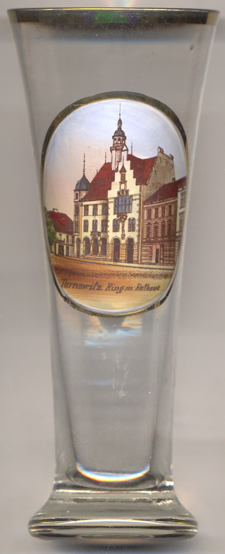
The Historicist  town hall [left, no. 3824] in Tarnowskie Góry's
central market square was built in 1896–1898 in place of an earlier district court building. The architect was
Hermann Guth from Berlin. In 1994, the roof was renovated and the turret was reconstructed. The
main façade of the town hall was renovated in 2010.
town hall [left, no. 3824] in Tarnowskie Góry's
central market square was built in 1896–1898 in place of an earlier district court building. The architect was
Hermann Guth from Berlin. In 1994, the roof was renovated and the turret was reconstructed. The
main façade of the town hall was renovated in 2010.
[https://de.wikipedia.org/wiki/Tarnowskie_Góry, https://en.wikipedia.org/wiki/Tarnowskie_Góry;
https://pl.wikipedia.org/wiki/Ratusz_w_Tarnowskich_Górach]
![[scale]](lineal.jpg)