
|
|
| ÖSTERREICH | AUSTRIA |
| Bundesland: Niederösterreich | Lower Austria |
| Bezirk: Lilienfeld |
map →


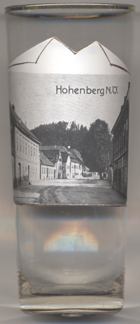 Hohenberg is situated at an elevation of 488 m in the valley of the Unrechttraisen, one of the two source rivers of the river Traisen,
at the foot of the Türnitzer Höger in the Mostviertel region of Lower Austria. The district town Lilienfeld is
located about 13 km to the north. The municipality has a population of about 1,500 (2021).
Hohenberg is situated at an elevation of 488 m in the valley of the Unrechttraisen, one of the two source rivers of the river Traisen,
at the foot of the Türnitzer Höger in the Mostviertel region of Lower Austria. The district town Lilienfeld is
located about 13 km to the north. The municipality has a population of about 1,500 (2021).
Hohenberg castle, of which today only ruins remain, was probably founded in the 13th century. The feudal territory comprised today's
cadastral community Hohenberg and most of the neighbouring municipality of Sankt Aegyd am Neuwalde. Hohenberg already had
market rights in 1325, and the Hohenberg parish was founded in the same year.The castle was destroyed in 1619 during the Thirty Years' War
(1618–1648). After the end of manorialism, the modern municipality was establieshed in 1648, comprising the cadastral communities of
Hohenberg and Innerfahrafeld, including the localities Andersbach, Furthof, Hohenberg, Hofamt and Innerfahrafeld.
[https://de.wikipedia.org/wiki/Hohenberg_(Nieder%C3%B6sterreich);
http://www.hohenberg.gv.at/Historisches_Hohenberg/Geschichte_und_Bilder;
https://de.wikipedia.org/wiki/Ruine_Hohenberg]
![[scale]](lineal.jpg)