
|
|
| DEUTSCHLAND | GERMANY |
| Bundesland: Baden-Württemberg | |
| Regierungsbezirk: Stuttgart | |
| Landkreis: Ostalbkreis |
map →

 Neuler is situated at an elevation of 518 m on a ridge between the rivers Kocher and Jagst about 7 km southwest of
Ellwangen and about 10 km north of Aalen, the administrative centre of the district Ostalbkreis. The municipality has a population
of about 3,200 (2020).
Neuler is situated at an elevation of 518 m on a ridge between the rivers Kocher and Jagst about 7 km southwest of
Ellwangen and about 10 km north of Aalen, the administrative centre of the district Ostalbkreis. The municipality has a population
of about 3,200 (2020).
The earliest known mention of Neuler in a written document dates from 1113. Until 1803 it belinged to the territories of the prince-provost of Ellwangen. Following the secularisation of the ecclesiastical territories in Germany in 1803, these territories, and with it Neuler, became part of the Electorate (1806 Kongdom) of Württemberg. Neuler became part of the district Ellwangen. In 1938 it became part of the district Aalen, which in 1973 was merged with most parts of the former district Schwäbisch Gmünd and small parts of the former districts Crailsheim and Backnang to become the new district Ostalbkreis.
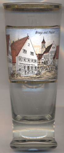
The Catholic  parish church Sankt Benedikt [background centre] was built in Baroque style in 1746
in place of an older, Gothic church.
parish church Sankt Benedikt [background centre] was built in Baroque style in 1746
in place of an older, Gothic church.
[https://de.wikipedia.org/wiki/Neuler;
https://www.schwaebischealb.de/attraktionen/katholische-pfarrkirche-st.-benedikt]
![[scale]](lineal.jpg)