|
|
| UNITED STATES OF AMERICA | |
| MASSACHUSETTS | |
| Plymouth County |
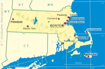
map →
|
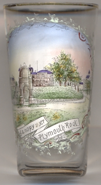
Plymouth is situated on Plymouth Bay in southeastern Massachusetts,
approximately 5 miles north of the Cape Cod Canal. As of the 2000 census, the town had a
total population of about 51,700. Plymouth is one of the two county seats of Plymouth county, the other
county seat being Brockton in the northwestern part of the county.
The town was founded by the Pilgrim fathers who had landed here in 1620. Unable to reach the land they had contracted for, they anchored (November 21) at the site of Provincetown. Because they had no legal right to settle in the region, they drew up the Mayflower Compact, creating their own government. The settlers soon discovered Plymouth Harbor, on the western side of Cape Cod Bay and made their historic landing on December 21; the main body of settlers followed on December 26. The first settlement was called New Plymouth, later Plymouth, after their point of departure, Plymouth in Devonshire, England. The colony contained roughly what is now Bristol County, Plymouth County, and Barnstable County. Half the colony failed to survive the first winter, but the remainder lived on and prospered. The Plymouth Colony existed until 1691 when the Massachusetts Bay Colony got its new charter.
|
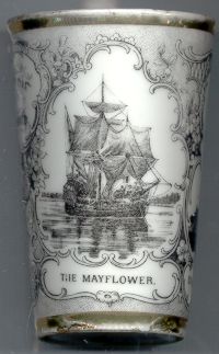
In 1957 a close replica of the Mayflower, the Mayflower II, was built in 1957 by England as a gift to America and sailed from Plymouth, England, to Plymouth, Massachusetts, where it is now on view. This was the only time that Mayflower II has sailed accross the Atlantic. In the contemporary documents no mention is made of the exact location of the site of landing of the Mayflower in Plymouth harbour. It was only more than one hundred yeras later, in 1741, that Plymout Rock was pointed out as the site that was supposed to be the first solid land on which the Pilgrims set foot upon their arrival in the New World.
|
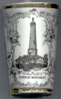
The The monument was designed by architect Alden Frink. Construction began in 1872 and was completed in 1898. The plaster model for the statue of Myles Standish was created by S.J. O'Kelly of Boston. In 1924, lightning struck the statue of Myles Standish, destroying the head and right arm. Two years later, a replacement head was cut and repairs was completed in 1927. In 1980, however, the monument had to be closed as the spiral staircase was deemed unsafe. Funds were appropriated in 1986 to refurbish and restore the well-known landmark in time for the 350th anniversary of the incorporation of Duxbury (1637). When the building is open, visitors can climb 125 steps to a small viewing area at the top offering a panoramic view of the South Shore, the five-mile-long Duxbury Beach, Plymouth Harbor, and the Blue Hills off to the northwest.
|
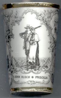
Alden was one of the first settlers of Duxburrough or Duxborough, known today as Duxbury Massachusetts, where he lived for most of his life. From 1633 until 1675 he was assistant to the governor of the colony, frequently serving as acting governor and also sat on many juries, including one of the two witch trials in the Plymouth Colony. John Alden married Priscilla Mullens in 1623. At the time of his death at Duxbury on September 12, 1687, Alden was the last male survivor of the signers of the Mayflower Compact of 1620, and the penultimate survivor of The Mayflower's company. John Alden and Priscilla are remembered chiefly because of a popular legend, put into verse in 1858 as "The Courtship of Miles Standish" by Henry Wadsworth Longfellow. According to the poem, John Alden won Priscilla's hand in marriage after first wooing her on behalf of his friend, Standish. However, there is no historic proof of this legend.
|
[Texts adapted from http://en.wikipedia.org/wiki/Plymouth,_Massachusetts, http://en.wikipedia.org/wiki/Plymouth_Colony, http://pilgrims.net/plymouth/history/, http://pilgrims.net/plymouth/history/mayflower.html, http://en.wikipedia.org/wiki/Mayflower, http://www.mass.gov/dcr/parks/southeast/mssm.htm, http://www.duxburysails.com/infop/stand.html, http://en.wikipedia.org/wiki/John_Alden, http://en.wikipedia.org/wiki/Priscilla_Mullens] | ||||||||
![[scale]](lineal.jpg)
 The Mayflower [right]
carried the Separatist Puritans, later known as pilgrims, to Plymouth, MA, in 1620. The 180-ton vessel
was about 12 years old and had been in the wine trade. It was chartered by John Carver, a leader of the
Separatist congregation at Leiden, Holland, who had gone to London to make arrangements for the
voyage to America. The ship was made ready at Southampton with a passenger list that included
English Separatists, hired help (among them Myles Standish, a professional soldier, and John Alden, a cooper),
and other colonists who were to be taken along at the insistence of the London businessmen who were helping to
finance the expedition.
The Mayflower left Plymouth again on April 15, 1621, and arrived back in England on May 16.
It is likely that the ship was broken up for scrap lumber after the death of its owner in 1623.
The Mayflower [right]
carried the Separatist Puritans, later known as pilgrims, to Plymouth, MA, in 1620. The 180-ton vessel
was about 12 years old and had been in the wine trade. It was chartered by John Carver, a leader of the
Separatist congregation at Leiden, Holland, who had gone to London to make arrangements for the
voyage to America. The ship was made ready at Southampton with a passenger list that included
English Separatists, hired help (among them Myles Standish, a professional soldier, and John Alden, a cooper),
and other colonists who were to be taken along at the insistence of the London businessmen who were helping to
finance the expedition.
The Mayflower left Plymouth again on April 15, 1621, and arrived back in England on May 16.
It is likely that the ship was broken up for scrap lumber after the death of its owner in 1623.