
|
|
| ČESKÁ REPUBLIKA | CZECH REPUBLIC |
| Jihočeský kraj | South Bohemia (České Budějovice) region |
| Okres: Strakonice |
map →
 Vodňany is situated at an elevation of 398 m on the right bank of the river Blanice, about 24&nbsl;km southeast of the
district town Strakonice and about 29 km northwest of the regional capital, České Budějovice.
The municipality has a population of about 7,000 (2021).
Vodňany is situated at an elevation of 398 m on the right bank of the river Blanice, about 24&nbsl;km southeast of the
district town Strakonice and about 29 km northwest of the regional capital, České Budějovice.
The municipality has a population of about 7,000 (2021).
A fishermens' village, Vodna, origianted at thisplace around the turn of the 12th to 13th century. In 1327, the rights of patronage were confered to the monastery of Schlägl. In 1336, the village obtained the status and privilages of a town. As a royal town, Vodňany, together with Písek and České Budějovice was one of the centres of power of the Bohemian crown. During the Hussite Wars it was conquered by the Hussites in 1420 and subsequently it became an important stronghold of the Taborites. In 1661, the princes of Schwarzenberg purchased Vodňany and their later residence Hluboka nad Vltavou. Since 1993, the town is the seat of the Research Institute for Fisheries and Hydrobiology of the University of South Bohemia in České Budějovice.
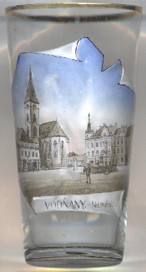
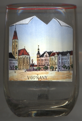
The  deanary church of the Nativity of Our Lady [left, no. 4288: left] was first mentioned in 1317.
The church was restored in Gothic revival style in 1894–1897 by the architect Josef Mocker.
deanary church of the Nativity of Our Lady [left, no. 4288: left] was first mentioned in 1317.
The church was restored in Gothic revival style in 1894–1897 by the architect Josef Mocker.
[https://de.wikipedia.org/wiki/Vod%C5%88any]
![[scale]](lineal.jpg)