
|
|
| DEUTSCHLAND | GERMANY |
| Bundesland: Freistaat Sachsen | Saxony |
| Landkreis: Erzgebirgskreis |
map →

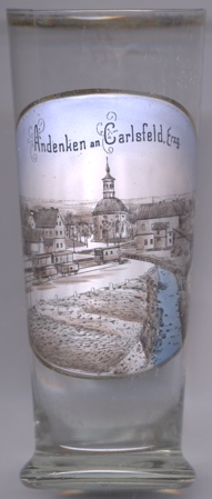 Carlsfeld is situated at an elevation of 537 m in the extreme southwest of the district Erzgebirgskreis of Saxony, about 7 km
south of Eibenstock and about 35 km southwest of the district town Annaberg-Buchholz. As of January 2010, Carlsfeld
has a population of 710 and is part of the municipality of Eibenstock.
Carlsfeld is situated at an elevation of 537 m in the extreme southwest of the district Erzgebirgskreis of Saxony, about 7 km
south of Eibenstock and about 35 km southwest of the district town Annaberg-Buchholz. As of January 2010, Carlsfeld
has a population of 710 and is part of the municipality of Eibenstock.
The settlement was founded in 1677 for the workers of newly established hammer mills. The hammer mills were closed in 1820 but were replaced by glass-making factories. Hollow glass making continued until 1979. From 1897 until 1967 Carlsfeld was the terminus of the narrow-gauge railway Wilkau-Haßlau–Carlsfeld. In 1997 Carlsfeld obtyined the official status as a state-approved resort place.
The Lutheran  Trinitatiskirche (church of the Holy Trinity) [centre] is considerd to be the earliest
prototype of the Frauenkirche in Dresden. The church was built between 1684 and 1688 on an elongated octogonal plan.
The pulpit altar from 1688 is considered one of the earliest and most valuable in Saxony. In the years 1843, 1958 and finally 1996–2000 the
church was extensively restored. It has been a listed building since the 1970s. In addition to religious services, the church is also used for
cultural events.
Trinitatiskirche (church of the Holy Trinity) [centre] is considerd to be the earliest
prototype of the Frauenkirche in Dresden. The church was built between 1684 and 1688 on an elongated octogonal plan.
The pulpit altar from 1688 is considered one of the earliest and most valuable in Saxony. In the years 1843, 1958 and finally 1996–2000 the
church was extensively restored. It has been a listed building since the 1970s. In addition to religious services, the church is also used for
cultural events.
[https://de.wikipedia.org/wiki/Carlsfeld_(Eibenstock);
https://de.wikipedia.org/wiki/Trinitatiskirche_(Carlsfeld)]
![[scale]](lineal.jpg)