
|
|
| ČESKÁ REPUBLIKA | CZECH REPUBLIC |
| Jihomoravský kraj | South Moravia (Brno) region |
| Okres: Vyškov |
map →
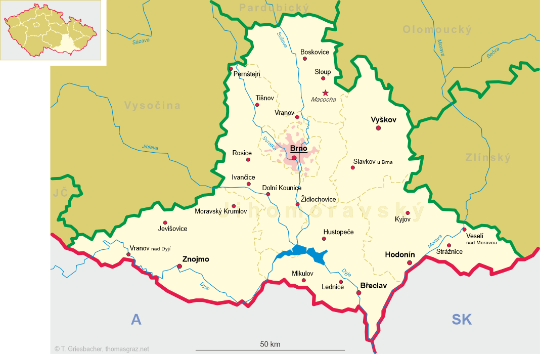
Vyškov (German: Wischau) is situated at an elevation of 245 m in the so-called Vyškov Gate, formed by the depression between the Western Carpathian Mountains in the east and the Bohemian massif (Drahanská vrchovina) in the west, in the northeast of the South Moravia region, about 30 km northeast of the regional capital Brno. The municipality has a population of about 20,700 (2021). Vyškov is the seat of administration of the homonymous district.
 The first written mention dates from 1141. Located on the crossroads of trade route from Brno to Olomouc and
Kroměříž, it was acquired by the bishops of Olomouc in the first half or the 13th century
who owned it for more than 600 years. In the mid-13th century, Vyškov obtained the privileges of a town. Vyškov was fortified in the
mid-14th century and the stone walls were built in the 15th century. During the Hussite Wars, the town was conquered and ravaged by the Hussites.
During the Thirty Years' War (1648–1648), the town was twice captured by Swedish troops and in 1643 was completely plundered. Vyškov
recovered and achieved its greatest development during the late 17th century. In 1805, Vyškov castle was the meeting place of Emperor
Alexander I of Russia and Holy Roman Emperor Francis II (1806 Emperor Francis I of Austria). After the Napoleonic Wars, the town expanded
and the fortifications were partially demolished. In 1941–1942, the neighbouring municipalities of Brňany, Dědice (with Hamiltony and
Pazterna), Křeckovice and Nosálovice (with Nouzka) were incorporated into the municipality of Vyškov. Brňany, Dědice
and Křeckovice tried to separate from the municipality in 1945, but this was rejected by the local committee of Vyškov. Efforts to make these
parts independent continued in the following years, but were not successful. Opatovice was incorporated into Vyškov in 1980, Lhota, Pařezovice
and Rychtárov followed in 1986.
The first written mention dates from 1141. Located on the crossroads of trade route from Brno to Olomouc and
Kroměříž, it was acquired by the bishops of Olomouc in the first half or the 13th century
who owned it for more than 600 years. In the mid-13th century, Vyškov obtained the privileges of a town. Vyškov was fortified in the
mid-14th century and the stone walls were built in the 15th century. During the Hussite Wars, the town was conquered and ravaged by the Hussites.
During the Thirty Years' War (1648–1648), the town was twice captured by Swedish troops and in 1643 was completely plundered. Vyškov
recovered and achieved its greatest development during the late 17th century. In 1805, Vyškov castle was the meeting place of Emperor
Alexander I of Russia and Holy Roman Emperor Francis II (1806 Emperor Francis I of Austria). After the Napoleonic Wars, the town expanded
and the fortifications were partially demolished. In 1941–1942, the neighbouring municipalities of Brňany, Dědice (with Hamiltony and
Pazterna), Křeckovice and Nosálovice (with Nouzka) were incorporated into the municipality of Vyškov. Brňany, Dědice
and Křeckovice tried to separate from the municipality in 1945, but this was rejected by the local committee of Vyškov. Efforts to make these
parts independent continued in the following years, but were not successful. Opatovice was incorporated into Vyškov in 1980, Lhota, Pařezovice
and Rychtárov followed in 1986.
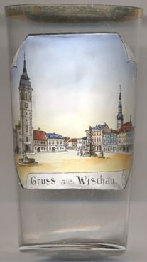
The  town hall [left, no. 4460: left] in Masarykovo Square is the landmark of Vyškov.
It was built in Renaissance style in 1569. It also features stucco decorations from the 18th century.
town hall [left, no. 4460: left] in Masarykovo Square is the landmark of Vyškov.
It was built in Renaissance style in 1569. It also features stucco decorations from the 18th century.
The church of the Assumption of the Virgin Mary [background right] is the main church
of Vyškov. The original late Gothic church was built in 1464–1466 and was rebuilt in Baroque style in 1773. A Gothic portal from the original
church has been preserved. The chapel of Saint Odile was added in 1692.
See also Вишково/Vyškovo, Ukraine.
[https://de.wikipedia.org/wiki/Vy%C5%A1kov, https://en.wikipedia.org/wiki/Vy%C5%A1kov;
https://en.wikipedia.org/wiki/Vy%C5%A1kov_Gate]
![[scale]](lineal.jpg)