
|
|
| ÖSTERREICH | AUSTRIA |
| Bundesland: Niederösterreich | Lower Austria |
| Bezirk: Neunkirchen |
map →

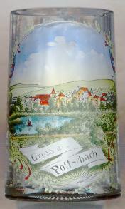 Pottschach is situated at an elevation of 427 m in the lower valley of the river Schwarza in southeastern Lower Austria.
Since 1974 it is part of the municipality of Ternitz.
Pottschach is situated at an elevation of 427 m in the lower valley of the river Schwarza in southeastern Lower Austria.
Since 1974 it is part of the municipality of Ternitz.
The oldest known written document that mentions Pottschach dates from 1094. However, archeological finds demonstrate that the area was already inhabitated in the Stone Age. The oldest church seemed to have been built in the 9th century. Pottschach castle was founded in the 16th century. In 1864, after the end of manorialism, Pottschach became an independent municipality. During the 19th and early 20th century Pottschach was a popular summer resort in southern Lower Austria, especially after a station on the Southern Railroad was opened in 1842. In 1974, Pottsch became part of the municipality of Ternitz.
The  parish church Sankt Dionysius [centre left] goes back to a Karolingian church of the 9th century.
The tower was built in 1520–1526. At the same time, the walls of the nave were heightened and closed with a Gothic vaulting, which still can be
seen today. The Lady Chapel and the sacristy were added in the 17th century and parts of the church were remodeled in Baroque style.
parish church Sankt Dionysius [centre left] goes back to a Karolingian church of the 9th century.
The tower was built in 1520–1526. At the same time, the walls of the nave were heightened and closed with a Gothic vaulting, which still can be
seen today. The Lady Chapel and the sacristy were added in the 17th century and parts of the church were remodeled in Baroque style.
Pottschach castle [centre right] goes back to a moated castle which (indirectly) was mentioned first
in 1134. After 1539 the old castle was replaced by the present, Renaissance, structure. After 1830/1832 the old moat was filied in and parts of the
lower castle were removed.
[https://de.wikipedia.org/wiki/Pottschach;
https://de.wikipedia.org/wiki/Pfarrkirche_Pottschach;
https://de.wikipedia.org/wiki/Schloss_Pottschach]
![[scale]](lineal.jpg)