
|
|
| ÖSTERREICH | AUSTRIA |
| Bundesland: Niederösterreich | Lower Austria |
| Bezirk: Lilienfeld |
map →

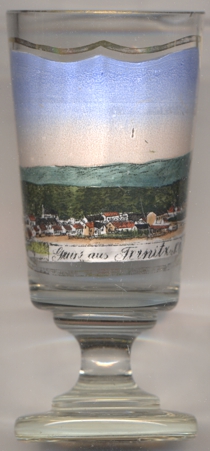 Ternitz is situated at an elevation of 396 m in the lower Schwarza valles at the edge of the Steinfeld plain in southeastern
Lower Austria. The municipality has a population of about 14,600 (2021) and is divided into the cadastral districts Dunkelstein, Flatz,
Holzweg, Mahrersdorf, Pottschach, Putzmannsdorf, Raglitz, Rohrbach am Steinfelde, St. Johann am Steinfelde and
Sieding.
Ternitz is situated at an elevation of 396 m in the lower Schwarza valles at the edge of the Steinfeld plain in southeastern
Lower Austria. The municipality has a population of about 14,600 (2021) and is divided into the cadastral districts Dunkelstein, Flatz,
Holzweg, Mahrersdorf, Pottschach, Putzmannsdorf, Raglitz, Rohrbach am Steinfelde, St. Johann am Steinfelde and
Sieding.
The area was first mentioned in 1352 as Tehannts and very likely was already densely populated at that time. However, in the ensuing
centuries it largely lost its importance. It only began to grow again when it obtained a station on the Southern Railroad in 1842 and after
a hammer mill was founded in 1847. The Ternitz iron and steel works (later 'Schoeller-Bleckmann steelworks') were founded in 1866. Hence,
the steel industry became the most important economic factor for the place. In 1923, the three former municipalities St. Johann am Steinfeld,
Dunkelstein and Rohrbach am Steinfeld were merged into the new municipality of Ternitz, which in 1948 obtained the status of a town. The
neighbouring municipalities of Flatz and Sieding were merged into Ternitz 1969, Pottschach
and Raglitz followed in 1974.
[https://de.wikipedia.org/wiki/Ternitz]
![[scale]](lineal.jpg)