
|
|
| DEUTSCHLAND | GERMANY |
| Bundesland: Freistaat Sachsen | Saxony |
| Landkreis: Mittelsachsen |
map →

 Penig is situated at an elevation of 231 m on the river Zwickauer Mulde in western Saxony.
The place was first mentioned as Wissepnig in a document of 1004.
Because Penig was located at the old salt trading route from Halle to Prague,
the Burgaves of Altenburg, who had been in possession of the area between 1170 and 1326 systematically
promoted the development of the settlement. Penig was first mentioned as a market place in 1301, and as a town in 1313.
When the Burgraves of Altenburg became extinct, the Burgraves of Leisnig took over the estates around 1329.
The status of Penig as a town was renewed and confirmed in 1455. The ground plan of the old town of Penig still is the same as that of the medieval town.
The majority of the buildings, however, dates from the 18th and 19th century.
Penig is situated at an elevation of 231 m on the river Zwickauer Mulde in western Saxony.
The place was first mentioned as Wissepnig in a document of 1004.
Because Penig was located at the old salt trading route from Halle to Prague,
the Burgaves of Altenburg, who had been in possession of the area between 1170 and 1326 systematically
promoted the development of the settlement. Penig was first mentioned as a market place in 1301, and as a town in 1313.
When the Burgraves of Altenburg became extinct, the Burgraves of Leisnig took over the estates around 1329.
The status of Penig as a town was renewed and confirmed in 1455. The ground plan of the old town of Penig still is the same as that of the medieval town.
The majority of the buildings, however, dates from the 18th and 19th century.
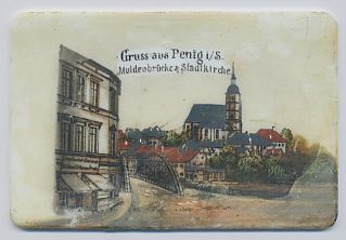 The most prominent edifice of Penig is the
  town church 'Zu unser Lieben Frauen auf dem Berge' (Our Lady on the Hill).
The church goes back to a funeral chapel that was built in 1280. This chapel was remodelled into the present church by the addition of the church tower and the
Late Gothic nave in 1476–1515. Treasures of the church are the magnificent Renaissance high altar of 1564 and the baptismal font of 1609.
The wooden ceiling, devided into 70 panels and ornated with paintings of biblical scenes, was created in 1688.
town church 'Zu unser Lieben Frauen auf dem Berge' (Our Lady on the Hill).
The church goes back to a funeral chapel that was built in 1280. This chapel was remodelled into the present church by the addition of the church tower and the
Late Gothic nave in 1476–1515. Treasures of the church are the magnificent Renaissance high altar of 1564 and the baptismal font of 1609.
The wooden ceiling, devided into 70 panels and ornated with paintings of biblical scenes, was created in 1688.
The iron Mulde river bridge was constructed in 1880. The first, wooden, bridge at this place was built in 1380, the first stone bridge
was built in 1527. The iron bridge depicted on the glasses was demolished to be replaced by a concrete bridge in 1939, which in turn was replaced by a new construction
in 2001.
![[scale]](lineal.jpg)