
|
|
| ÖSTERREICH | AUSTRIA |
| Bundesland: Niederösterreich | Lower Austria |
| Bezirk: Neunkirchen |
map →

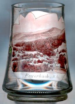
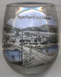 Payerbach is situated at an elevation of 493 m in the valley of the river Schwarza in southern Lower Austria at the foot of the mountains
Rax and Schneeberg, and marks the beginning of the tunnel and viaduct part of the railway line across the Semmering pass,
the world's first mountain adhesion railway built in 1848–1854 by Carl Ritter von Ghega. The municipality has a population of about 2,000 (2022).
It comprises the cadastral districts Kreuzberg, Küb, Payerbach (with Werning and Geyerhof), Pettenbach and Schmidsdorf (with Mühlhof and
Schlöglmühl).
Payerbach is situated at an elevation of 493 m in the valley of the river Schwarza in southern Lower Austria at the foot of the mountains
Rax and Schneeberg, and marks the beginning of the tunnel and viaduct part of the railway line across the Semmering pass,
the world's first mountain adhesion railway built in 1848–1854 by Carl Ritter von Ghega. The municipality has a population of about 2,000 (2022).
It comprises the cadastral districts Kreuzberg, Küb, Payerbach (with Werning and Geyerhof), Pettenbach and Schmidsdorf (with Mühlhof and
Schlöglmühl).
The  parish church Sankt Jakobus der Ältere (St. James the Greater)
[left, no. 823: background right] goes back to a church of 1350.
The present church in late Gothic style dates from the late 16th century.
parish church Sankt Jakobus der Ältere (St. James the Greater)
[left, no. 823: background right] goes back to a church of 1350.
The present church in late Gothic style dates from the late 16th century.
![[scale]](lineal.jpg)