
|
|
| ÖSTERREICH | AUSTRIA |
| Bundesland: Niederösterreich | Lower Austria |
| Bezirk: Neunkirchen |
map →

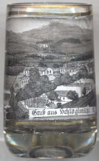 Schlöglmühl is situated at an elevation of 508 m on the left bank of the river Schwarza, about 3 km east of
Reichenau an der Rax and about 16 km southwest of the district town Neunkirchen.
Schlöglmühl is part of Schmidsdorf, a cadastral district of the municipality of Reichenau an der Rax.
Schlöglmühl is situated at an elevation of 508 m on the left bank of the river Schwarza, about 3 km east of
Reichenau an der Rax and about 16 km southwest of the district town Neunkirchen.
Schlöglmühl is part of Schmidsdorf, a cadastral district of the municipality of Reichenau an der Rax.
Schlöglmühl was especially known for its paper and cellulose factory, which operated from 1852 until 1982. The paper mill was
one of the largest in the Austro-Hungarian Monarchy.
[http://fallingrain.com/world/AU/03/Schloglmuhl.html;
https://de.wikipedia.org/wiki/Payerbach,
https://www.meinbezirk.at/neunkirchen/c-regionauten-community/damals-und-heute-schloeglmuehl-papierfabrik-mit-schlot-und-umliegenden-gebaeuden-1851-1982-bis-2021_a4800098]
![[scale]](lineal.jpg)