
|
|
| ÖSTERREICH | AUSTRIA |
| Bundesland: Niederösterreich | Lower Austria |
| Bezirk: Gänserndorf |
map →

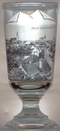 Zistersdorf is situated at an elevation of 199 m in the East of the Weinviertel region of Lower Austria.
The place was first mentioned in a document of 1160. The town itself was founded in the first half of the 13th century (the town walls, which still exist in parts, are
mentioned already in 1284). It originally thrived as an important border stronghold at the eastern border of Austria. Since 1931, petrol production caused an economic upswing.
Zistersdorf is situated at an elevation of 199 m in the East of the Weinviertel region of Lower Austria.
The place was first mentioned in a document of 1160. The town itself was founded in the first half of the 13th century (the town walls, which still exist in parts, are
mentioned already in 1284). It originally thrived as an important border stronghold at the eastern border of Austria. Since 1931, petrol production caused an economic upswing.
The  parish church Kreuzerhöhung (Elevation of the Cross) [background left] was built in Baroque style 1627–1640 as the church of the Franciscan monastery. In 1810, the monastery of
Zwettl purchased the monastery. Since 1811, the church served as the parish church of Zistersdorf.
parish church Kreuzerhöhung (Elevation of the Cross) [background left] was built in Baroque style 1627–1640 as the church of the Franciscan monastery. In 1810, the monastery of
Zwettl purchased the monastery. Since 1811, the church served as the parish church of Zistersdorf.
The castle [background centre] was first mentioned in 1278. What can be seen of the castle today mostly dates to the 17th and 18th century.
It is used for a vocational school since 1960.
The old Town Hall [background right, barely visible] was erected in 1760 in Baroque style. In 1945 it was destroyed but has been rebuilt
according to the original plans. Today it houses a satellite station of the Gänserndorf district administration.
The pilgrimage church Maria Moos (Our Lady of the Moss) was erected in 1160. The original Romanesque church
was replaced by a Gothic church in the 13th/14th century. During the 18th century the interior was remodelled in splendid Baroque style.
Until 1811 the church served as the parish church of Zistersdorf.
![[scale]](lineal.jpg)