
|
|
| DEUTSCHLAND | GERMANY |
| Bundesland: Niedersachsen | Lower Saxony |
| Landkreis: Celle |
map →
 Celle is situated at an elevation of 40 m on the river Aller in the south of the administrative district Lüneburg of Germany's state of Lower Saxony.
"Kellu", which was first mentioned in AD 993, was located a few kilometers east of the present town, which was founded
in 1292. In 1378 the town became the residence of the Dukes of Saxe-Wittenberg, and since 1433 it was
the residence of the Dukes of Braunschweig-Lüneburg.
Celle ceased to be a residence town after the death in 1705 of Duke Georg Wilhelm of Braunschweig-Lüneburg-Celle,
and his countries reverted to Lüneburg-Calenberg (since 1692 Electorate of Hannover).
With the annexation in 1866 of Hannover by Prussia, Celle became part of the Prussian province Hannover.
Celle is situated at an elevation of 40 m on the river Aller in the south of the administrative district Lüneburg of Germany's state of Lower Saxony.
"Kellu", which was first mentioned in AD 993, was located a few kilometers east of the present town, which was founded
in 1292. In 1378 the town became the residence of the Dukes of Saxe-Wittenberg, and since 1433 it was
the residence of the Dukes of Braunschweig-Lüneburg.
Celle ceased to be a residence town after the death in 1705 of Duke Georg Wilhelm of Braunschweig-Lüneburg-Celle,
and his countries reverted to Lüneburg-Calenberg (since 1692 Electorate of Hannover).
With the annexation in 1866 of Hannover by Prussia, Celle became part of the Prussian province Hannover.
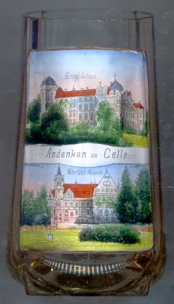
The  Ducal castle [top] goes back to a stronghold of the 13th century, which was transformed into
a residence castle during the 14th century. Beginning in 1530 it was remodeled into a Renaissance residence. Between 1665 and 1705 the
castle received its present Baroque appearance. In 1705 the castle ceased to be a residence and from then on was used only sporadically,
but in 1839/1840 it became a summer residence of the Hannover court. The chapel of the castle was built in 1485 and
is the only original early protestant court chapel in Germany. It is also an important example of North German Renaissance style.
Ducal castle [top] goes back to a stronghold of the 13th century, which was transformed into
a residence castle during the 14th century. Beginning in 1530 it was remodeled into a Renaissance residence. Between 1665 and 1705 the
castle received its present Baroque appearance. In 1705 the castle ceased to be a residence and from then on was used only sporadically,
but in 1839/1840 it became a summer residence of the Hannover court. The chapel of the castle was built in 1485 and
is the only original early protestant court chapel in Germany. It is also an important example of North German Renaissance style.
The state museum (Vaterländisches Museum) [bottom] was founded in 1892.
The museum, today named Bomann-Museum after its first director, Wilhelm Bomann, is one of the largest and most important
museums of northern Germany.
![[scale]](lineal.jpg)