
|
|
| ÖSTERREICH | AUSTRIA |
| Bundesland: Steiermark | Styria |
| Bezirk: Bruck-Mürzzuschlag |
map →

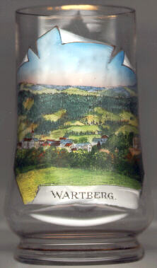
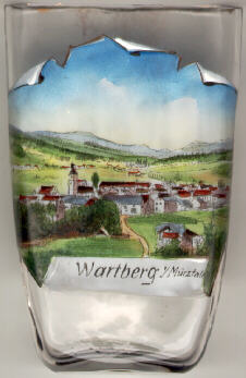 Wartberg im Mürztal is situated at an elevation of 584 m in the valley of the river Mürz.
The earliest mention of a manor "ad Wartperch" dates from 1158. At this place a hill or low mountain (in German: 'Berg') narrows the valley so much that a fortified lookout tower (German: 'Warte') could easily control the road that lead along the river and here had to climb up and down this hill. On 1 January 2015, the formerly independent municipalities of Mitterdorf im Mürztal, Veitsch and Wartberg im Mürztal were merged to become the new municipality of Sankt Barbara im Mürztal.
The  parish church Sankt Erhard [centre left]
was first mentioned in 1407 as filial church of Krieglach
and became a parish in 1785. The present church was built 1730–1731 by the
architect Remigius Horner on the model of the abbey church of Pöllau. After a fire
in 1735 the church tower was rebuilt in 1737.
parish church Sankt Erhard [centre left]
was first mentioned in 1407 as filial church of Krieglach
and became a parish in 1785. The present church was built 1730–1731 by the
architect Remigius Horner on the model of the abbey church of Pöllau. After a fire
in 1735 the church tower was rebuilt in 1737.
![[scale]](lineal.jpg)