
|
|
| ÖSTERREICH | AUSTRIA |
| Bundesland: Steiermark | Styria |
| Bezirk: Bruck-Mürzzuschlag |
map →

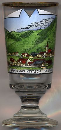
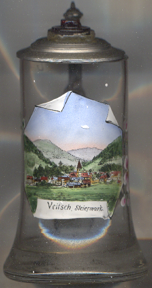 Veitsch is situated at an elevation of 664 m at the foot of the mountain Hohe Veitsch (1,981 m)
in the district Bruck-Mürzzuschlag in northeastern Styria.
The municipality has a population of about 2,600 (2010).
Veitsch is situated at an elevation of 664 m at the foot of the mountain Hohe Veitsch (1,981 m)
in the district Bruck-Mürzzuschlag in northeastern Styria.
The municipality has a population of about 2,600 (2010).
The area at first belonged to the Benedictine monastery of Sankt Lambrecht near Murau and later was in possession of several different noble families, among them the lords of Stubenberg and the counts of Herberstein. The first atempts to mine for copper date from 1584. Similar attempts were made in 1719 and 1735 but failed again. Mining for iron was discontinued in 1860. A graphite mine operated from 1880 until 1924. This more or less unlucky mining history changed in 1881 when magnesite was discovered. The Veitscher Magnesitwerke A.G. was founded in 1899 and was one of the most important economical factors for the community. The mines were closed in 1967/68. On 1 January 2015, the formerly independent municipalities of Mitterdorf im Mürztal, Veitsch and Wartberg im Mürztal were merged to become the new municipality of Sankt Barbara im Mürztal.
The  parish church Sankt Veit (St. Vitus) [left, no. 2606: background right]
goes back to a church that was first mentioned in 1184. The present church dates from the late Gothic period (
15th century). Until 1959 the church was appropriated to the monastery of Sankt Lambrecht.
parish church Sankt Veit (St. Vitus) [left, no. 2606: background right]
goes back to a church that was first mentioned in 1184. The present church dates from the late Gothic period (
15th century). Until 1959 the church was appropriated to the monastery of Sankt Lambrecht.
[https://de.wikipedia.org/wiki/Veitsch, http://www.veitsch.at/cms/index.php?idcatside=4http://www.eurovia.tv/home/images/stories/Mariazell/wallfahrtsorte_steiermark.pdf]
![[scale]](lineal.jpg)