
|
|
| ČESKÁ REPUBLIKA | CZECH REPUBLIC |
| Moravskoslezský kraj | North Moravia and Silesia (Ostrava) region |
| Okres: Karviná |
map →

 Český Těšín is situated at an elevation of 270 m on the right bank of the river Olše (Polish: Olza, German: Olsa), which here formes the border between
the Czech Republic and Poland. Across the river lies the Polish town of Cieszyn, once part of the historic town Cieszyn (Polish) / Těšín (Czech) / Teschen (German).
The municipality of Český Těšín has a population of about 25,100 (2013).
Český Těšín is situated at an elevation of 270 m on the right bank of the river Olše (Polish: Olza, German: Olsa), which here formes the border between
the Czech Republic and Poland. Across the river lies the Polish town of Cieszyn, once part of the historic town Cieszyn (Polish) / Těšín (Czech) / Teschen (German).
The municipality of Český Těšín has a population of about 25,100 (2013).
 The place was first mentioned in documents in the 12th century. The town
itself was founded 1292 near a castle on the left bank of the river. Later, the
historic town centre developed on the right bank of the river. The town obtained
the municipal rights in 1364. The Duchy of Teschen belonged to the Bohemian
Crown from 1625. The title of Duke of Teschen was borne
by Leopold Joseph of Lorraine from 1722, then by Emperor Franz I (Franz Stephan of Lorraine,
husband of Maria Theresia of Austria), then by their daughter Maria Christine and
her husband Duke Albrecht von Sachsen-Teschen.
The Peace of Teschen (13 May 1779) ended the Bavarian War of Succession between
Prussia and Austria.
The place was first mentioned in documents in the 12th century. The town
itself was founded 1292 near a castle on the left bank of the river. Later, the
historic town centre developed on the right bank of the river. The town obtained
the municipal rights in 1364. The Duchy of Teschen belonged to the Bohemian
Crown from 1625. The title of Duke of Teschen was borne
by Leopold Joseph of Lorraine from 1722, then by Emperor Franz I (Franz Stephan of Lorraine,
husband of Maria Theresia of Austria), then by their daughter Maria Christine and
her husband Duke Albrecht von Sachsen-Teschen.
The Peace of Teschen (13 May 1779) ended the Bavarian War of Succession between
Prussia and Austria.
After the dissolution of the Austro-Hungarian Monarchy, the historic part of the town on the right bank [see glass] became part of Poland (Cieszyn), whereas the new town and the industrial area on the left bank became of part of the Czechoslovak Republic (Český Těšín). After the Treaty of Munich, Český Těšín was occupied by Poland (together with the Czech towns of Karviná, Orlová, Bohumín and Petrovice). In 1939 Cieszyn was occupied by Germany and became part of Upper Silesia (except Český Těšín, which became part of the Protectorate Bohemia and Moravia). Since 1945, the river Olza (Czech: Olše, German: Olsa) again marks the border between Poland (Cieszyn) and the Czechoslovak (today Czech) Republic (Český Těšín).
The Austrian politician Rudolf Ramek (1881–1941; Chancellor of Austria 1924–1926) was born in Teschen / Cieszyn / Těšín.
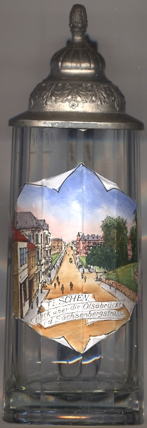
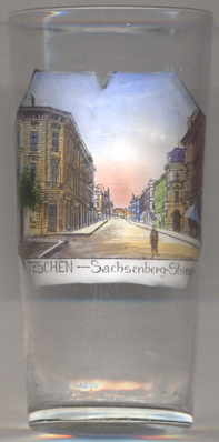
The pictures on glasses no. 2843 [left] and no. 3186 [right] show views
of the street
 Sachsenberg
The short stretch of the street depicted in the foreground of the picture on glass no. 2843 [left],
then named Schlossgasse (Castle Street), today is named Zamkova and is part of the Polish town of
Cieszyn. The two streeets are connected by the bridge across the river Olsa (about where the trees
are depicted), which today marks the border between the Czech Republic and Poland.
![[scale]](lineal.jpg)