
|
|
| ÖSTERREICH | AUSTRIA |
| Bundesland: Niederösterreich | Lower Austria |
| Bezirk: Sankt Pölten |
map →

 Frankenfels is situated at an elevation of 464 m on the stream Nattersbach, a left contributary of the Pielach, in the south of the district
Sankt Pölten, about 32 km southwest of Lower Austria's capital, Sankt Pölten. The municipality has a population
of about 1,900 (2021).
Frankenfels is situated at an elevation of 464 m on the stream Nattersbach, a left contributary of the Pielach, in the south of the district
Sankt Pölten, about 32 km southwest of Lower Austria's capital, Sankt Pölten. The municipality has a population
of about 1,900 (2021).
The upper Pielach valley was colonised in the 11th century. Around 1300, Franchenvels was mentioned for the first time. A large part of the farms that are still in operation today had already been mentioned in the Wallsee land register from 1449. The division of the region into 'Rotten' has existed since 1629. In 1655, Frankenfels was granted the status of a market town. With the opening in 1906/1907 of the second section of the Mariazellerbahn, the narrow gauge railroad from Sankt Pölten to Mariazell and Gußwerk, Frankenfels was connected to the railway network.
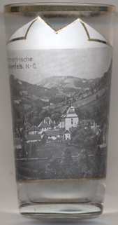
The  parish church Sankt Margaretha [left, no. 4034: far right] was originally built in 1290 in
Romanesque style. At first it was a filial church of the parish Kilb until in 1429 it became a parish itself. In the mid-15th century, a new, larger,
Gothic choir and a tower were added. In 1723–1727 the church was enlarged in Baroque style. The present main altar was created in 1777.
Schwarzenbach an der Pielach, which until then was part of the parish, became an indepenent parish in 1787, the parish
Puchenstuben was separated from Frankenfels in 1804.
parish church Sankt Margaretha [left, no. 4034: far right] was originally built in 1290 in
Romanesque style. At first it was a filial church of the parish Kilb until in 1429 it became a parish itself. In the mid-15th century, a new, larger,
Gothic choir and a tower were added. In 1723–1727 the church was enlarged in Baroque style. The present main altar was created in 1777.
Schwarzenbach an der Pielach, which until then was part of the parish, became an indepenent parish in 1787, the parish
Puchenstuben was separated from Frankenfels in 1804.
[https://de.wikipedia.org/wiki/Frankenfels;
https://de.wikipedia.org/wiki/Mariazellerbahn]
![[scale]](lineal.jpg)