
|
|
| DEUTSCHLAND | GERMANY |
| Bundesland: Baden-Württemberg | |
| Regierungsbezirk: Freiburg | |
| Landkreis: Ortenaukreis |
map →

 Offenburg is situated at an elevation of 163 m where the Kinzig valley opens into the Upper Rhine Plain about 67 km southwest of
Karlsruhe and 96 km westsouthwest of Stuttgart. Offenburg is the capital of the district
Ortenaukreis; the municipality has a population of about 60,900 (2021).
Offenburg is situated at an elevation of 163 m where the Kinzig valley opens into the Upper Rhine Plain about 67 km southwest of
Karlsruhe and 96 km westsouthwest of Stuttgart. Offenburg is the capital of the district
Ortenaukreis; the municipality has a population of about 60,900 (2021).
Remains of Roman settlements have been discovered within the city's territory in recent times. The oldest known written dcument mentioning the place dates from 1148. Offenburg had already been declared a Free Imperial City by 1240. In September 1689, the city was totally destroyed by the French during the Nine Years War. Following the end of the Holy Roma Empire (Reichsdeputationshauptschluss of 1803) and the subsequent reorganisation of the German states, Offenburg lost its status as a Free Imperial City and fell under the rule of the Grand Duchy of Baden. During the outbreak of the Revolutions of 1848, the "Offenburger Programm", which consisted of thirteen demands "in the name of the people of Baden", was put forward on 12 September 1847. This was the first known demand for democracy in Germany. Along with the Karlsbad (today Karlovy Vary, Czech Republic) Decrees, the Offenburger Program demanded basic and human rights as well as freedom of the press and a progressive income tax structure. During World War I Offenburg was one of the first cities to experience the effects of aerial bombardment. After the war, during the Occupation of the Ruhr, French troops occupied Offenburg in 1923–1924, because it fell within the perimeter of the Kehl bridgehead. Following the rise to power of the NSDAP in the 1930s, Offenburg's Jewish population fell victim to acts of repression; those members of the Jewish population that had not managed to emigrate were deported to Gurs concentration camp in October 1940 and from there to Auschwitz during 1942. From 1945 Offenburg was part of the French occupation zone (see map). With the creation in 1949 of the Federal Republic of Germany it became part of Germany's state of Baden-Württemberg. Since the creation of the Federal Republic, Offenburg has continually developed in size, inhabitants and prosperity. Between 1971 and 1975 eleven adjacent villages were incorporated into the municipality.
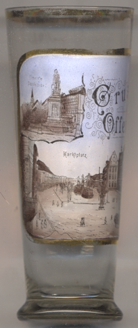
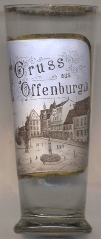
The main picture on glass no. 4226 [left] shows a view of the
 old market square
The monument for Francis Drake [top left inset] was created in 1853 by the sculptor André Friedrich.
It was thus the first monument to Drake in history. The reason for erecting a monument to the English seafarer was most likely not that he mostly operated
as pirate but at the time (not today any more) was seen as responsible for the introduction of potatoes into Europe. This seemed highly important at the
time, few years after the years of hunger that had led to the Revolution of 1848. Popularly, the monument soon became known as the 'potato man'. In 1939,
at the beginning of World War II, the Nazis destroyed the statue because they did not want to see a monument to an Englishman.
[https://de.wikipedia.org/wiki/Offenburg, https://en.wikipedia.org/wiki/Offenburg;
https://www.offenburg.de/de/zu-gast-in-offenburg/touristinfo/sehenswertes/plaetze-in-offenburg/;
https://www.google.com/url?sa=t&rct=j&q=&esrc=s&source=web&cd=&ved=2ahUKEwi3o7uIx7n5AhUqgP0HHZAVA20QFnoECBsQAQ&url=https%3A%2F%2Fwww.gedenkstaetten-suedlicher-oberrhein.de%2Fwp-content%2Fuploads%2F2021%2F02%2F2021-01-29_Ortenau_Seite_24.pdf&usg=AOvVaw2yhECBeAaGeBEVnAIun4sG]
![[scale]](lineal.jpg)