
|
|
| DEUTSCHLAND | GERMANY |
| Bundesland: Baden-Württemberg | |
| Regierungsbezirk: Stuttgart | |
| Landkreis: Heilbronn |
map →

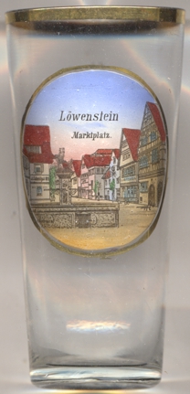 Löwenstein is situated at an elevation of 385 m in the Swabian-Franconian Forest in the northeast of Baden-Württemberg,
about 14 km southeast of Heilbronn and about 38 km northeast of Stuttgart. The
municipality has a population of about 3,400 (2021).
Löwenstein is situated at an elevation of 385 m in the Swabian-Franconian Forest in the northeast of Baden-Württemberg,
about 14 km southeast of Heilbronn and about 38 km northeast of Stuttgart. The
municipality has a population of about 3,400 (2021).
Löwenstein castle was founded around 1090 by the counts of Calw as an administrative seat on the salt trading
route from Heilbronn to Hall. The counts of Löwenstein, a collateral line of the counts
of Calw, were first mentioned in 1123. When the counts of Calw had become extinct, the last male heir of the counts of Löwenstein sold his
domains to the bishopric of Würzburg, which itself sold the domains to the Habsburgs in 1281. In 1287 Löwenstein
was granted the privileges of a town. One half of the county of Löwenstein was sold to the electorate of the Palatinate in 1382, the second half
was purchased by the Palatinate in 1441. The county of Löwenstein was subsequently refounded within the Wittelsbach-Palatinate family. During
the Landshut War of Succession Löwenstein was occupied in 1504 by Württemberg, but was handed back to the to the
counts of Löwenstein in 1510. Whe the counts also obtained the county of Wertheim, they changed their name to Löwenstein-Wertheim. After
the mediatisation Löwenstein in 1806 became part of the Kingdom of Württemberg where it was placed first in the district
Backnang and later, in 1810, in the district Weinsberg. Since 1938 it is part of the district
Heilbronn.
[https://de.wikipedia.org/wiki/L%C3%B6wenstein]
![[scale]](lineal.jpg)