
|
|
| DEUTSCHLAND | GERMANY |
| Bundesland: Baden-Württemberg | |
| Regierungsbezirk: Stuttgart | |
| Landkreis: Schwäbisch Hall |
map →

Schwäbisch Hall is situated at an elevation of 301 m at the river Kocher in northeastern Baden-Württemberg. The communities of Bibersfeld, Eltershofen, Gailenkirchen, Gelbingen, Sulzdorf, Tüngental and Weckrieden were incorporated into the municipality of Schwäbisch Hall in 1970 and each have a separate district council. Schwäbisch Hall is the administrative seat of the county district of the same name and has a population of about 36,500 (2004).
The original name of the was Hall. During the Middle Ages the name gradually changed to Schwäbisch Hall. Although the country around Schwäbisch Hall belonged to the Frankonian Circle of the Holy Roman Empire, the Imperial City of Hall belonged to the Swabian Circle. When Hall became part of Württemberg in 1802, the adjective "Schwäbisch" was dropped from the name, but was eventually re-introduced officially in 1934.
The earliest written mention of Hall is a forged document that was dated to 1037 but most likely was written towards the end of the 11th century. The saline near the river was the reason for the foundation of Hall in the strategically unfavourable location in the deep valley. At that time the town was in possession of the counts of Comburg-Rothenburg. When the family became extinct, Hall came passed to the Hohenstaufen dynasty around 1116. The first secured mention then is found in a document of 1156. Under Emperor Friedrich I (Barbarossa) a mint was founded in Hall. The coins minted here were thin silver coins of small denominations (Haller Pfennig = Heller). Nevertheless, they became one of the most popular coins throughout the Empire. The earliest mention of Hall as a town dates from 1204. Both the saline and the mint provided the basis for a flourishing period of the town, which, in 1280, obtained the status of a Free Imperial City. The City effectively increased its domains during the 14th, 15th and 16th centuries. Between 1523 and 1543 the Reformation was introduced in the town. From about 1595 until the end of the old empire in 1802/04 the territory in possession of Schwäbisch Hall covered an area of 330 km² with about 21,000 people.
In 1802 Schwäbisch Hall was annexed by Württemberg and lost its status as an Imperial City. The villages in its former territory were separated from the town and were incorporated into other administrative districts. The saline became a property of the state and remained so until it was finally closed in 1924. The industrialisation did not change much in Hall, it basically only could proved jobs for those that lost their jobs in the traditional trades. Even the railroad, which connected Hall to Heilbronn since 1862, could not improve the economic situation. However, it provided the basis for tourism and the development of Hall into a resort town.
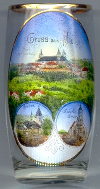 The Benedictine monastery
  Comburg [top picture] was founded around 1078
by the counts of Comburg-Rothenburg at the site of their former castle. The monastery was subordinate to the diocese
of Würzburg. The monastery flourished until the 13th century; thereafter it gradually declined
until it practically went bankrupt in 1326. The economic situattion of the monastery only improved in the second half
of the 14h century. Like Schwäbisch Hall, the monastery was immediate to the Empire and belonged to the Swabian Circle
of the Empire. After the secularisation of 1802 the monastery was closed in 1803. Its treasures were remelted and the
precious library today is part of the Württemberg State Library. Although part of the monastery buildings were demolished
in the 19th century, the monastery still is a well-preserved ensemble of buildings from the 11th until the 18th centuries.
The Baroque monastery church of St. Nicholas was built in 1706–1715 in place of the previous, Romanesque, basilica
of 1088 of which the three towers have remained. Parts of the interior decorations have been preserved from the old basilica
such as a gilded copper antependium and the large flambeaux, both of around 1130, and the tomb of the benefactors from 1180.
As part of the community of Steinbach Comburg was incorporated into Hall in 1930.
Comburg [top picture] was founded around 1078
by the counts of Comburg-Rothenburg at the site of their former castle. The monastery was subordinate to the diocese
of Würzburg. The monastery flourished until the 13th century; thereafter it gradually declined
until it practically went bankrupt in 1326. The economic situattion of the monastery only improved in the second half
of the 14h century. Like Schwäbisch Hall, the monastery was immediate to the Empire and belonged to the Swabian Circle
of the Empire. After the secularisation of 1802 the monastery was closed in 1803. Its treasures were remelted and the
precious library today is part of the Württemberg State Library. Although part of the monastery buildings were demolished
in the 19th century, the monastery still is a well-preserved ensemble of buildings from the 11th until the 18th centuries.
The Baroque monastery church of St. Nicholas was built in 1706–1715 in place of the previous, Romanesque, basilica
of 1088 of which the three towers have remained. Parts of the interior decorations have been preserved from the old basilica
such as a gilded copper antependium and the large flambeaux, both of around 1130, and the tomb of the benefactors from 1180.
As part of the community of Steinbach Comburg was incorporated into Hall in 1930.
 The bottom right picture on glass no. 1762 shows the town
The saline
![[scale]](lineal.jpg)