
|
|
| ČESKÁ REPUBLIKA | CZECH REPUBLIC |
| Ústecký kraj | Ústí nad Labem region |
| Okres: Most |
map →
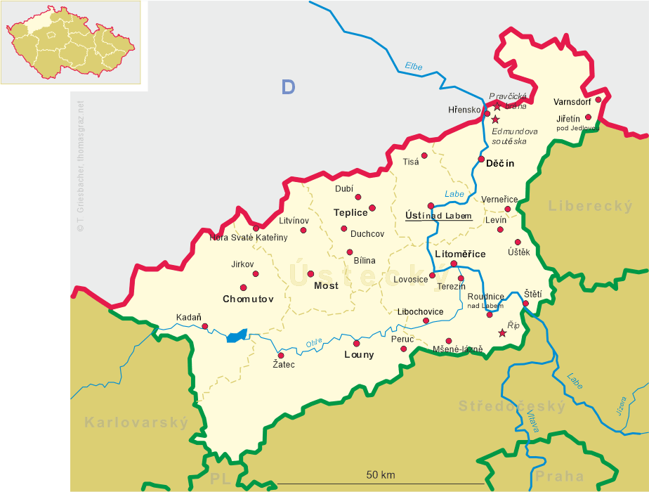
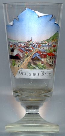 Most (German: Brüx) is situated at an elevation of 235 m in northwestern Bohemia.
The origins of the town go back to the 9th and 10th century when a first fortification was built on the castle hill
to secure a trading path from Prague to Freiberg in Saxony.
Wooden bridges enabled the transport of goods through the swamps of the area.
These bridges also are the origin of the town's name: both the Czech word most and the German word Brücke mean 'bridge'.
Most (German: Brüx) is situated at an elevation of 235 m in northwestern Bohemia.
The origins of the town go back to the 9th and 10th century when a first fortification was built on the castle hill
to secure a trading path from Prague to Freiberg in Saxony.
Wooden bridges enabled the transport of goods through the swamps of the area.
These bridges also are the origin of the town's name: both the Czech word most and the German word Brücke mean 'bridge'.
Around 1238 the castle and village came in possession of the Přemyslide rulers of Bohemia. The oldest existing seal of the town dates from 1257. During the Middle Ages Most became a rich and prosperous town. At the end of the 14th century vineyards were laid out and the population became mostly German. In 1416 the charter of the town was renewed. A large fire destroyed Most almost completely in 1515, but the town was rebuilt in remarkably short time. During the Thirty Years's War (1618–1648) Most suffered severely and the castle was conquered for the first (and last) time in its history by Swedish troops. After the war the castle and the fortifications were pulled down because it was feared that they would attract more enemies if they remained intact. The town, however, lost most of its importance.
It took until the 19th century until the town began to grow considerably again. Mining for coal began in 1811 and the mining activities greatly increased after Most was connected to the railrod system in 1870. After World War I Most was occupied by Czech troops and was incorporated into the new state of Czechoslovakia in 1918. During World War II the old town suffered heavy damages. The final destruction came after further extensions of the mining activities after 1964. The complete old town was demolished between 1967 and 1982 and a new town was built nearby. The only building that has survived from the historic town is the deanery church of the Assumption of the Virgin Mary from the early 16th century. The church was saved by a spectacular technical operation supported by the UNESCO. The whole building (except the church tower) was moved in one piece to a new site 860 m away from the old location and its tower was rebuilt.
The  church of the Assumption of the Virgin Mary [near left, no. 4680: foreground]
goes back to an earlier church from about 1253/1257 that burnt down in 1515. Of this previous, Gothic three-naved basilica only the eastern crypt
and the internal peripheral brickwork of the western tower remained. The construction of the present church began in 1517 and the principal structure
was completed in 1549. The Renaissance portals were installed in the 2nd half of the 16th century. Another large fire in 1578 again caused
severe destructions, which were finally repaired in 1602. A new roof was put on the church in 1650. During renovations carried out in 1880–1883
the interior was remodeled in Gothic revival style.
[https://en.wikipedia.org/wiki/Church_of_the_Assumption_of_the_Virgin_Mary_(Most)]
church of the Assumption of the Virgin Mary [near left, no. 4680: foreground]
goes back to an earlier church from about 1253/1257 that burnt down in 1515. Of this previous, Gothic three-naved basilica only the eastern crypt
and the internal peripheral brickwork of the western tower remained. The construction of the present church began in 1517 and the principal structure
was completed in 1549. The Renaissance portals were installed in the 2nd half of the 16th century. Another large fire in 1578 again caused
severe destructions, which were finally repaired in 1602. A new roof was put on the church in 1650. During renovations carried out in 1880–1883
the interior was remodeled in Gothic revival style.
[https://en.wikipedia.org/wiki/Church_of_the_Assumption_of_the_Virgin_Mary_(Most)]
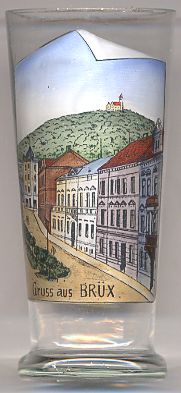
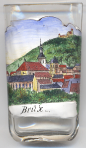
Hněvín castle on Castle hill (Zámecký vrch or vrch Hněvín)
[near left, no. 4463, right, no. 2523: background, and above, no. 4680: background right] dates back to the
12th century, but archeological investigations have discovered some remains that date already from the 9th century.
The Treaty of Cheb (1459) awarded the castle to Georg (Jiří) of Poděbrady.
In 1480 the castle was sold to the von Weitmühl (z Veitmile) family. In 1595 the castle came in possession of the town.
The castle as we see it today is a reconstruction in Romantic style which was built in the 19th century. The tall lookout tower
is a beloved landmark of Most.
![[scale]](lineal.jpg)