
|
|
| DEUTSCHLAND | GERMANY |
| Bundesland: Saarland | |
| Stadtverband: Saarbrücken |
map →
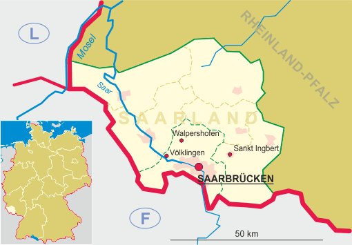
Saarbrücken is situated at an elevation of 190 m on the river Saar. It is the capital of Germany's state Saarland and is the administrative seat of the Stadtverband Saarbrücken, a special municipal collective, similar to a Landkreis (district or county). Saarbrücken has a population of about 181,000 (2005).
The castellum Sarabrucca was first mentioned in a document of 999, a donation of the castle to the bishopric of Metz. The castle was the origin of the County of Saabrücken, which emerged around 1120. Under the counts of Saarbrücken, the town received its charter.
In 1353 Saarbrücken came in possession of the Walramic line of the House of Nassau. Two years later, the countries were divided between Nassau-Wiesbaden-Idstein and Nassau-Weilburg-Saarbrücken; the latter line was partitioned in 1442 between Nassau-Saarbrücken (Elder Line), and Nassau-Weilburg (Elder Line). After a temporary partition between 1547 and 1559, Saarbrücken was inherited by Weilburg in 1574. As the Counts of Nassau-Weilburg in 1526 had introduced the Reformation in their country, Saarbrücken also became Lutheran in 1574. The Younger Line of Nassau-Saarbrücken originated in 1629. This line was itself partitioned in 1629 into Nassau-Saarbrücken, Nassau-Ottweiler and Nassau-Usingen. Saarbrücken was inherited by Ottweiler in 1723, and together with Ottweiler fell to Nassau-Usingen (since 1688 a principality) in 1723. Only between 1735 and 1797 the County of Nassau-Usingen-Saarbrücken was partitioned from Usingen (1806 a Duchy; and finally inherited by Weilburg in 1816).
After 1741 Saarbrücken enjoyed a prosperous time. The collieries and iron smelting facilities provided the basis for the wealth of the county. In 1793 Saarbrücken was occupied by French troops and after the Treaties of Campo Formio (1797) and Lunéville (1801) the county was incorporated into France. After the Congress of Vienna (1815) the region was awarded to the Kingdom of Prussia (Province Grand Duchy of the Lower Rhine, 1822 Rhine Province).
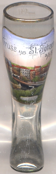
With a contract of 1908, the formerly independent towns of Saarbrücken, Sankt Johann and Malstatt-Burbach were combined into a new, single municipality. However, the mayors of Saarbrücken and St. Johann disagreed about the future name of the combined community and decided to solve their dispute in a duel. Both men survived and the name Saarbrücken was finally chosen. The duel reportedly was the last one in Germany.
After World War I the Saarland was put under administration of the League of Nations. After a referendum the region was returned to Germany in 1935. During World War II Saarbrücken suffered severe damages by bomb raids in 1944. After the war the region was put under a French military government. In 1947 the region obtained a limited autonomy, but formed a customs union with France. In the Saar Statute of 1954, France and Germany agreed to put the Saar region under administation of the Western European Union. However, in a referendum in 1955 the population dismissed the Saar Statute and voted for rejoining Germany. In 1957 the Saarland was admitted into the Federal Republic of Germany as its 10th federal state.
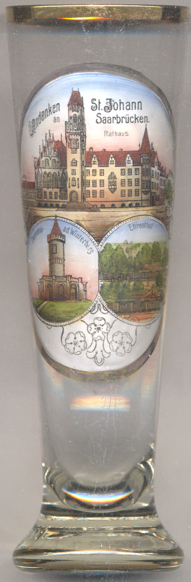
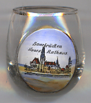
The former  Town Hall of Sankt Johann [left, no. 3352: top picture, and right,
no. 2888] today is the town hall of Saarbrücken. It was built in 1897–1900, designed by Georg von
Hauberrisser in late Gothic revival style. Further buildings by Georg von Hauberrisser depicted on glasses of this
collections are the new town hall of Munich and the Herz-Jesu-Kirche in
Graz.
Town Hall of Sankt Johann [left, no. 3352: top picture, and right,
no. 2888] today is the town hall of Saarbrücken. It was built in 1897–1900, designed by Georg von
Hauberrisser in late Gothic revival style. Further buildings by Georg von Hauberrisser depicted on glasses of this
collections are the new town hall of Munich and the Herz-Jesu-Kirche in
Graz.
[https://de.wikipedia.org/wiki/Rathaus_St._Johann]
The Winterberg monument [bottom left picture] was a soldiers' monument on the Winterberg
hill. The monument on the artificial hill was erected in 1872–1874 and commemorated the victory of the Prussian army
in the Battle of Spichern (6 August 1870) during the French-German War. The tower had a total height of 30 metres.
During World War II the tower was blown up by the German army so as not to serve as a reference point for the Allied
forces. The pedestal of the monument was reconstructed in 1975.
[https://de.wikipedia.org/wiki/Winterbergdenkmal]
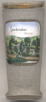 The Ehrental (Honour Valley) [far left, no. 3352: bottom right picture, and below, no. 4201],
was laid out as a soldiers' cemetery
in 1870 shortly after the Battle of Spichern, of which is was part of the battlefield. Around 1900 it was known as
Kaiser-Wilhelm-Park. Between 1957 and 1960, after the return of the Saarland to the Federal Republic of Germany,
it was redesigned as a landscape park for the binational (French-German) Bundesgartenschau (Federal Garden Exhibition) of 1960
as a symbol of durable friendship between the former enemies. The garden today is named Deutsch-Französischer
Garten (German-French Garden). The soldiers' cemetry for the dead of both sides is located in the upper part of the
park.
The Ehrental (Honour Valley) [far left, no. 3352: bottom right picture, and below, no. 4201],
was laid out as a soldiers' cemetery
in 1870 shortly after the Battle of Spichern, of which is was part of the battlefield. Around 1900 it was known as
Kaiser-Wilhelm-Park. Between 1957 and 1960, after the return of the Saarland to the Federal Republic of Germany,
it was redesigned as a landscape park for the binational (French-German) Bundesgartenschau (Federal Garden Exhibition) of 1960
as a symbol of durable friendship between the former enemies. The garden today is named Deutsch-Französischer
Garten (German-French Garden). The soldiers' cemetry for the dead of both sides is located in the upper part of the
park.
[https://de.wikipedia.org/wiki/Deutsch-Französischer_Garten]
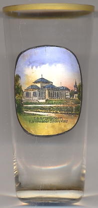
The Staatstheater Saarbücken [left]
was built in 1937–1938 by the architect Paul Otto August Baumgarten in neo-Classicist style.
Officially it was "donated" to the Saarland by the National Socialist government of Germany for having voted in the referendum
of 1935 for remaining with Germany. In fact, the city of Saarbrücken had to pay the major part of the costs.
The theatre was opened as "Gautheater Saarpfalz" in 1938. During World War II it was destroyed in 1942
and was restored after the war during the period of the French occupation under its new name "Staatstheater Saarbrücken".
[https://de.wikipedia.org/wiki/Staatstheater_Saarbrücken]
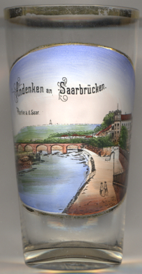
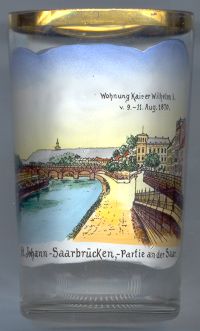
Glasses no. 3802 [near left] and no. 1980 [right] show a view of Saarbrücken on the river Saar.
The picture on glass no. 1980 [right] is labeled
"Wohnung Kaiser Wilhelm I. v. 9.–11. Aug. 1870 / St.-Johann-Saarbrücken, Partie an der Saar"
("Apartment [of] Emperor Wilhelm I from 9th to 11th August 1870 / St.-Johann-Saarbrücken, section at the Saar
river"). The glass must have been produced later. The date shown on the glass is shortly after the outbreak of the
French-Prussian War (19 July 1870). However, Wilhelm I, King of Prussia, was proclaimed first German Emperor on
18 January of the following year, one week after the French surrender (10 January 1871).
The Luisenbrücke [left] (on glass no. 2966 labeled Neue Brücke)
was built in 1862–1866. It was blown up during World War II and replaced by a new bridge in 1946/1947. After a renovation in 1962
it is now named Westspangenbrücke.
[http://www.regionalgeschichte.net/saarland/staedte-doerfer/orte-s/saarbruecken.html, http://bildarchiv.baw.de/cdm/ref/collection/wsv/id/4066, http://bildarchiv.baw.de/cdm/search/searchterm/Luisenbr%C3%BCcke]
![[scale]](lineal.jpg)