
|
|
| DEUTSCHLAND | GERMANY |
| Bundesland: Freistaat Sachsen | Saxony |
| Landkreis: Erzgebirgskreis |
map →

Pockau-Lengefeld is situated at an elevation of 440 m in the east of the district Erzgebirgskreis (Ore Mountains District) of Saxony. The municipallity was created on 1 January 2014 by merging the formerly independent municipalities of Pockau and Lengefeld. the entire municipality has a population of about 7,850 (2015).
 Pockau is situated at an elevation of 428 m in the Flöha valley where the river Schwarze Pockau flows into
the Flöha. Pockau has a population of about 3,800 (2013).
Pockau is situated at an elevation of 428 m in the Flöha valley where the river Schwarze Pockau flows into
the Flöha. Pockau has a population of about 3,800 (2013).
The village Packaw was first mentioned in 1365. Glass-making was already done here in the 15th century. During the Reformation period, Pockau became part of the parish of Lengefeld. Pockau was connected to the railroad in 1872/1875 (Flöha valley railroad from Flöha via Hetzdorf, Grünhainichen-Borstendorf, Pockau-Lengefeld and Marienberg to Reitzenhain at the border to Bohemia to lead on via Hora Sv. Šebastiána / Sebastiansberg, Křimov / Krima-Neudorf and Domina / Domina-Schönlind to Chomutov / Komotau). The village of Görsdorf was incorporated into Pockau in 1934. The village Marterbüschel was separted from Lengefeld and incorporated into the municipality of Pockau in 1948. In 1994 the neighbouring communities of Forchheim and Wernsdorf also became part of Pockau. On 1 January 2014 Pockau was merged with Lengefeld to become the new municipality of Pockau-Lengefeld. Pockau was officially recognized as a resort place in 1988.
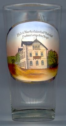
The picture on glass no. 2016 [left]
shows  Hotel
Hotel
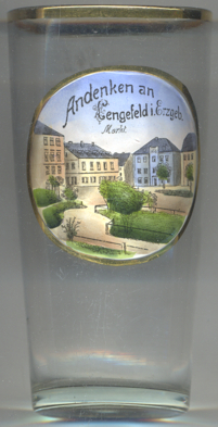 Lengefeld is situated at an altitude of 440 m on a hill west of the Flöha valley. It has a population of
about 4,200 (2013) and since 2014 is part of the combined municipality of Pockau-Lengefeld.
Lengefeld is situated at an altitude of 440 m on a hill west of the Flöha valley. It has a population of
about 4,200 (2013) and since 2014 is part of the combined municipality of Pockau-Lengefeld.
Lenginfelt was first mentioned in a written document in 1360, Lengefeld in 1369. The mining town
Lengefeld was founded in 1522 by the lords of Rauenstein castle. The mines were used for the production of iron, silver
and limestone; however, the never were as profitable as those of Annaberg or Marienberg.
Lengefeld town lost the status of a mining town in 1813, and in 1851 the last ore mine was closed. The production of
limestone, however, continues until today. In 1835 the village and the town of Lengefeld were united and until 1856
were part of the district Wolkenstein. Lippersdorf, Reifland and Wünschendorf were incorporated into Lengefeld
in 1999. On 1 January 2014 Lengefeld was merged with Pockau to become the new municipality of Pockau-Lengefeld.
[https://de.wikipedia.org/wiki/Pockau-Lengefeld, https://de.wikipedia.org/wiki/Pockau, https://de.wikipedia.org/wiki/Lengefeld;
https://de.wikipedia.org/wiki/Bahnstrecke_Reitzenhain–Flöha, https://de.wikipedia.org/wiki/Bahnstrecke_Chomutov–Vejprty/Reitzenhain;
https://www.pockau-lengefeld.de/lebendige-stadt/stadtportrait/ortsteile/pockau.html;
https://de.wikipedia.org/wiki/Lengefeld]
![[scale]](lineal.jpg)